Pricing Change
New pricing for orders of material from this site will come into place shortly. Charges for supply of digital images, digitisation on demand, prints and licensing will be altered.
Gansclet
Broch (Iron Age)(Possible)
Site Name Gansclet
Classification Broch (Iron Age)(Possible)
Alternative Name(s) Wic 192
Canmore ID 9079
Site Number ND34SW 7
NGR ND 33627 44415
Datum OSGB36 - NGR
Permalink http://canmore.org.uk/site/9079
- Council Highland
- Parish Wick
- Former Region Highland
- Former District Caithness
- Former County Caithness
ND34SW 7 33627 44415.
An artificial mound, evidently containing the ruin of a broch, lies partly beneath the house of Henry Taylor, Gansclet. It is about 70ft in diameter and 5ft in height, is turf-covered and has a number of flat stones protruding from it.
RCAHMS 1911.
Mr Stewart, occupier of the house once owned by Henry Taylor, sited the broch to a slight rise at ND 3361 4440 and described the removal of the mound and a broch-like structure 'about 30 years ago', the stone being used to build the road to the house.
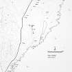
Site surveyed at 1:2500.
Visited by OS (R L) 25 April 1967.
(ND 3362 4441) Broch (NR) (site of)
OS 1:10,000 map, (1976)
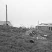
A large stony mound situated immediately NE of the farmhouse at Gansclet has previously been recorded as a broch. The mound measures at least 20m in diameter and 1.5m in height, but on the date of visit it was entirely shrouded in nettles and willow-herb.
(YARROWS04 962)
Visited by RCAHMS (JRS) 12 August 2004
Publication Account (2007)
ND34 5 GANSCLET ND/3362 4441
This possible broch in Wick, Caith-ness, was reported in 1910 as consisting of a mound 21.4m (70ft) in diameter, 1.5m (5ft) high and partly under the house which was thought to have contained a ruined broch [2]. It is supposed to have been removed in the 1930s to provide material for the approach road [1].
Sources: 1. NMRS site no. ND 34 SW 7: 2. RCAHMS 1911b, 145, no. 501.
E W MacKie 2007


