
Millburn


Dam (Period Unassigned), Mill (Period Unassigned)
Site Name Millburn
Classification Dam (Period Unassigned), Mill (Period Unassigned)
Alternative Name(s) Wic 202
Canmore ID 9075
Site Number ND34SW 66
NGR ND 33988 42096
Datum OSGB36 - NGR
Permalink http://canmore.org.uk/site/9075


- Council Highland
- Parish Wick
- Former Region Highland
- Former District Caithness
- Former County Caithness
ND34SW 66 33988 42096
A mill, 10,5m by 14m, ruinous with collapsed walls. Possibly modern.
C E Batey 1981.
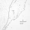
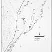
This ruined mill (YARROWS04 476) is situated on the left (E) side of the Mill Burn 395m ENE of Mains of Ulbster farmsteading (ND34SW 304). It measures 9.8m from E to W by 5.4m transversely over walls about 1m in thickness. These have been reduced to their lowest courses on the E, but stand to an external height of 1.7m on the W. There appear to be two opposed entrances situated towards the E end of the N and S walls respectively. There are the remains of a breached dam (YARROWS04 477) some 36m N of the mill.
The mill is depicted unroofed on both the 1st and 2nd editions of the OS 6-inch map (Caithness 1877, sheet xxix; 1907, sheet xxix).
(YARROWS04 476-7)
Visited by RCAHMS (JRS, ATW), 24 August 2004.
Project (1980 - 1982)
Field Visit (1981)
A mill, 10,5m by 14m, ruinous with collapsed walls. Possibly modern.
C E Batey 1981.

