
Scheduled Maintenance
Please be advised that this website will undergo scheduled maintenance on the following dates: •
Tuesday 3rd December 11:00-15:00
During these times, some services may be temporarily unavailable. We apologise for any inconvenience this may cause.
Hillhead


Farmstead (Period Unassigned)
Site Name Hillhead
Classification Farmstead (Period Unassigned)
Alternative Name(s) Wic 194b
Canmore ID 9074
Site Number ND34SW 65
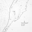
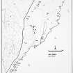
NGR ND 34421 43815
Datum OSGB36 - NGR
Permalink http://canmore.org.uk/site/9074


- Council Highland
- Parish Wick
- Former Region Highland
- Former District Caithness
- Former County Caithness
ND34SW 65 34421 43815.
A modern four to five roomed croft measuring 39 to 5m, its ruinous and largely turf-covered walls standing 2.8m high. Shown roofed in 1871.
C E Batey 1981; OS 6" map, Caithness, 1st ed., (1871)
The remains of this farmstead are situated in a field of improved pasture 150m S of Stonecroft and comprise the grass-grown wall-footings of a range measuring 37m from NW to SE by 5m transversely over all. The range, which contains five compartments, has been built on a slight slope that falls NW to SE.
The 1st edition of the OS 6-inch map (Caithness 1877, sheet xxx) depicts the range as two separate roofed structures of unequal length, and it also shows a subdivided garden plot to the SSW. The 2nd edition of the map shows no significant changes, save that the wall subdividing the garden is not shown (1907, sheet xxx).
(YARROWS04 453)
Visited by RCAHMS (ATW) 11 August 2004
Project (1980 - 1982)
Field Visit (1981)
A modern four to five roomed croft measuring 39 to 5m, its ruinous and largely turf-covered walls standing 2.8m high. Shown roofed in 1871.
C E Batey 1981; OS 6" map, Caithness, 1st ed., (1871)

