
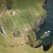
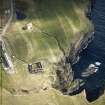
Whaligoe


Farmstead (Period Unassigned)
Site Name Whaligoe
Classification Farmstead (Period Unassigned)
Alternative Name(s) Wic 208; Whaligoe Mill
Canmore ID 9072
Site Number ND34SW 63
NGR ND 32264 40500
NGR Description ND 32263 40490 and ND 32264 40500
Datum OSGB36 - NGR
Permalink http://canmore.org.uk/site/9072


- Council Highland
- Parish Wick
- Former Region Highland
- Former District Caithness
- Former County Caithness
ND34SW 63 3226 4048.
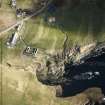
A croft, grass-covered and ruinous, comprising two buildings, 25 by 5 8m and 9.4 by 4.5m, each 0.4m in maximum height. Shown roofed in 1871.
OS 6" map, Caithness, 1st ed., (1871); C E Batey 1981.
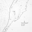
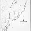
The remains of this farmstead, which comprise two buildings reduced to little more than footings, are situated in a field of pasture about 105m E of Whaligoe Mill (ND34SW 119). One of the buildings is a range (YARROWS04 754) containing a dwelling and a kiln-barn, and the other (YARROWS04 753) lies immediately to the NE. The range measures 19m from NW to SE by 3.8m within walls about 0.7m in thickness and 0.5m in height. The kiln-barn lies at its NW end and what was probably originally a dwelling is at the SE end. The kiln-barn comprises a rectangular compartment, which probably originally had opposed doorways on the NE and SW respectively, though only that on the SW is now visible, and the rounded end of the range housed the kiln. Little detail of the kiln can now be seen; the bowl is filled with grass-grown rubble and there is no flue visible within the interior of the barn. The probable dwelling measures 6.5m from NW to SE by 3m internally and has a central entrance in its SW side. In the SE corner of the interior there is a low grass-grown platform, the purpose of which is not known. This platform is edged with vertically set slabs up to 0.2m in height and it runs from the wall on the NE to a point about 1m short of the wall on the SW.
The range is depicted roofed on the 1st edition of the OS 6-inch map (Caithness 1877, sheet xxix), but it is shown unroofed on the 2nd edition of the map (1907, sheet xxix). The second building is not depicted on either map.
(YARROWS04 753, 754)
Visited by RCAHMS (JRS), 26 August 2004.
Project (1980 - 1982)

