
Pricing Change
New pricing for orders of material from this site will come into place shortly. Charges for supply of digital images, digitisation on demand, prints and licensing will be altered.
Braehead


Farmstead (Period Unassigned)
Site Name Braehead
Classification Farmstead (Period Unassigned)
Alternative Name(s) Wic 209
Canmore ID 9070
Site Number ND34SW 61
NGR ND 31922 40209
Datum OSGB36 - NGR
Permalink http://canmore.org.uk/site/9070


- Council Highland
- Parish Wick
- Former Region Highland
- Former District Caithness
- Former County Caithness
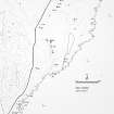
ND34SW 61 31922 40209.
A probable croft, 28 by 9.3m, in very poor condition, with the possible remains of a corn-drying kiln to the W. Shown partly roofed in 1871.
C E Batey 1981; OS 6" map, Caithness, 1st ed., (1871)
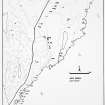
Nothing is visible of the small steading described by Batey and its site is now occupied by a large modern shed.
Visited by RCAHMS (JRS, ATW) 17 September 2004
Project (1980 - 1982)
Field Visit (1981)
A probable croft, 28 by 9.3m, in very poor condition, with the possible remains of a corn-drying kiln to the W. Shown partly roofed in 1871.
C E Batey 1981; OS 6" map, Caithness, 1st ed., (1871)

