
Ulbster, Dam


Dam (Period Unassigned)
Site Name Ulbster, Dam
Classification Dam (Period Unassigned)
Alternative Name(s) Broughwhin; Garrywhin
Canmore ID 9067
Site Number ND34SW 59
NGR ND 31250 41201
Datum OSGB36 - NGR
Permalink http://canmore.org.uk/site/9067


- Council Highland
- Parish Wick
- Former Region Highland
- Former District Caithness
- Former County Caithness
ND34SW 59 31250 41201
Dam probably for Whaligoe mill (ND34SW 119).
Visited by RCAHMS (GJD) 22 July 1987.
Site was also formerly ND34SW 115.
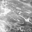
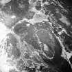
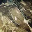
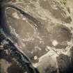
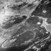
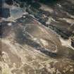
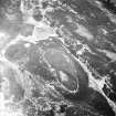
This dam is situated at the foot of the E flank of Warehouse Hill, immediately S of the Garrywhin fort (ND34SW 3). It once retained a very large pond that was used as a top-up reservoir for Loch Watenan, which in turn supplied water to the corn mill at Whaligoe (ND34SW 119). The dam comprises a thick stone-faced wall measuring 50m in length from N to S by up to 6m in thickness at the base and 2.5m in height.
(YARROWS04 67)
Visited by RCAHMS (JRS) 24 May 2004
A dam 49.6m long has been built across the base of two ridges, Broughwhin and Garrywhin, to create a large pond to the W. It has a stepped battered stone face with an earthen and rubble core, and measures up to 8m in thickness and 3.7m in external (E) height. A sluice through the thickest section of the dam controlled the outflow of water from the pond, and was supported by buttresses built against its W face; here the rubble core of the dam has been eroded. A short section of drystone wall runs obliquely across the dam towards its N end and was probably built to control the movement of livestock.
(YARROWS04 67)
Visited by RCAHMS (ARG, ATW) 16 June 2004

