
Yarrows


Boundary Stone (Period Unassigned), Fort (Period Unassigned), Quarry (Period Unassigned)
Site Name Yarrows
Classification Boundary Stone (Period Unassigned), Fort (Period Unassigned), Quarry (Period Unassigned)
Canmore ID 9062
Site Number ND34SW 54
NGR ND 30413 42265
Datum OSGB36 - NGR
Permalink http://canmore.org.uk/site/9062


- Council Highland
- Parish Wick
- Former Region Highland
- Former District Caithness
- Former County Caithness
ND34SW 54 30413 42265.
(ND 304 422) Fort, Yarrows: Towards the S end of the plateau a short distance to the NW of the highest of the Warehouse cairns (no. 551) are the ruins of a wall, stretching E-W for about 120', overgrown with peat and turf and in front of it on the E half is a ditch some 15' wide and 6' deep. An entrance, some 6' wide, cuts through the wall towards its W end. The wall is only recognisable elsewhere in places. In front of the defences at the S end is a glacis some 60' wide extending to the edge of the plateau.
RCAHMS 1911, visited 1910.
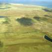
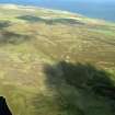
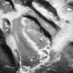
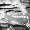
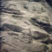
At ND 3042 4227 occupying the level summit of a plateau commanding wide views are traces of an enclosure, probably the remains of a fort. The plateau is roughly triangular measuring about 90.0m N-S by 40.0m maximum width with its E and W sides edge by low cliffs. The more easily approached S side has been cut off by a wall now heavily obscured by peat build up and visible as a bank about 2.5m wide in which one or two possible outer facing stones can be seen. The W end curves and continues N along the W side for about 10.0m where it fades out on the rocky slopes. Similarly in the E there are vague traces of it before it vanishes on the outcrop. There is no trace of it continuing elsewhere on the plateau. Near the SW corner is an entrance gap about 1.5m wide. Outside the wall are one or two quarry holes but it cannot be ascertained whether these are contemporary or later. Although the wall appears to be too slight to be a defensive structure, the situation is naturally strong, and the wall has probably been a fortification. The interior is featureless except for a modern ditched almost square enclosure near the N end which measures 7.5m E-W by 7.0m N-S between the centres of a ditch 0.4m wide and 0.3m deep cut into the peat.
Surveyed at 1:10,000.
Visited by OS (I S S) 13 March 1972.
(ND 3040 4225) Fort (NR)
OS 1:10,000 map, (1976)
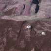
This fort (YARROWS04 230) is situated on a spur on the NW flank of an un-named hill 1km SSW of South Yarrows farmsteading (ND34SW 474). Irregular on plan, it measures about 85m from NNE to SSW by a maximum of 39m transversely at the broad S end within a low stone wall up to 1.2m in thickness and 0.4m in height. This wall tends to follow the edge of the natural scarp around the top of the hill and it appears to be continuous, except where its path is interrupted by exposures of outcrop. There is an entrance at the S end and there is another at the N end, where there is an outer wall. There is some robbing to the inner wall at the N end, possibly when the low cairn surmounted by a boundary stone was built. The boundary stone (YARROWS04 229) is an undressed sandstone block measuring 0.25m by 0.15m at ground-level and 1m in height. There are quarry scoops (YARROWS04 231) outside the S end of the enclosure and both inside and outside the bank on the E side. A shallow depression inside the N end of the enclosure is probably a tent stance.
(YARROWS04 229, 230, 231)
Visited by RCAHMS (AGCH) 30 June 2004
Note (19 February 2015 - 18 May 2016)
This enclosure occupies the crest of a craggy hillock forming the N spur of the high ground S of South Yarrows, and commands extensive views out to the N and E. Oval on plan, it measures about 90m from N to S by 40m transversely (0.27ha) within a single wall which follows the lip of the low crags along the E and W sides and returns sharply across the gentler slope at the S end. The course of the wall is only intermittently visible along the flanks, and where best preserved at the S end is marked by little more than a stony bank some 2.5m thick and 0.4m high; there is also what may be an entrance in the S end close to the W margin of the hillock. The interior is largely featureless, but there is a small trapezoidal enclosure of relatively recent date at the N end adjacent a marker stone set in a small cairn of stones. The handful of other enclosures in elevated positions in Caithness are all forts, but if that is truly the case here then the perimeter has been very heavily robbed.
Information from An Atlas of Hillforts of Great Britain and Ireland – 18 May 2016. Atlas of Hillforts SC2831

