
Black Isle, Blackstand Airfield


Building (20th Century), Hut (20th Century)
Site Name Black Isle, Blackstand Airfield
Classification Building (20th Century), Hut (20th Century)
Alternative Name(s) Fortrose Airfield
Canmore ID 90526
Site Number NH76SW 21.01
NGR NH 71199 60738
NGR Description NH 71199 60738 and NH 71793 61135
Datum OSGB36 - NGR
Permalink http://canmore.org.uk/site/90526


- Council Highland
- Parish Cromarty
- Former Region Highland
- Former District Ross And Cromarty
- Former County Ross And Cromarty
NH76SW 21.01 71199 60738 and 71793 61135
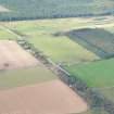
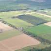
Much of the area used as a landing ground has now been planted with trees. Some buildings survive, notably at NH 71199 60738 and NH 71793 61135.
Information from RCAHMS (DE), October 2004
Three buildings linked to Blackstand Airfield are situated on the S side of the track leading from the B 9160 public road to Blackstand farmstead.
The buildings consist of a wooden hut (NH 71239 60748), the former guard house (NH 71259 60765) and what was appparently a toilet block at NH 71417 60878.
The wooden hut was during the post war period utilised by the Forestry Commission whilst they were undertaking the replanting of trees in the are. It measures 18m x 4.80m and stands 3.80m to the ridge and 2.52 to the eaves. There are three entrances, one at each end and one centrally posisitioned on the NW-facing elevation with six window openings 970mm x 1100mm in wooden frames, on each elevation of the hut.
Visited by RCAHMS (DE), 29 October 2008

