Accessibility

Font Size

100% 150% 200%

Background Colour

Default Contrast
Close Reset

Benbecula Airport, Airfield

Airfield (20th Century)

Site Name Benbecula Airport, Airfield

Classification Airfield (20th Century)

Alternative Name(s) Balivanich; Raf Benbecula; Benbecula Aerodrome; Port Adhair; Bheinn Na Faoghla

Canmore ID 90522

Site Number NF75NE 4

NGR NF 7870 5611

NGR Description Centred NF 7870 5611

Datum OSGB36 - NGR

Permalink http://canmore.org.uk/site/90522

Ordnance Survey licence number AC0000807262. All rights reserved.
Canmore Disclaimer. © Bluesky International Limited 2025. Public Sector Viewing Terms

Toggle Aerial | View on large map

Digital Images

General oblique aerial view centred on the airfield, taken from the W.
General oblique aerial view centred on the airfield, taken from the W.View of security gate from SSW.View of station from SSW.Interior.
Detail of plant room.View of officers mess from NE.Oblique aerial view centred on the village with the airfield adjacent, taken from the N.General oblique aerial view looking over Benbecula airport and Gramasdail towards The Little Minch beyond, taken from the NNW.Oblique aerial view centred on the village with the airfield adjacent, taken from the S.View of main entrance gate from SSW.General view of station from SW.General view of station from SW.View of station from SSW.View of W side of station from SW.General view of station from ESE.View over airfield from ESE.Interior.
View of guardroom/security office from N.View of officers mess from NE.Detail of nissen huts on SE perimeter.Detail of nissen huts on South East perimeterOblique aerial view centred on Balivanich village with Benbecula airfield adjacent, taken from the SE.View of E side of station from NNE.Oblique aerial view.Oblique aerial view.Oblique aerial view.General oblique aerial view looking across the bay of Culla towards the crofting township of Aird with the township of Balvanich and Benbecula aerodrome beyond, taken from the WSW.Oblique aerial view centred on the airfield with the township adjacent, taken from the N.View of E side of station from NNE.View of WW11 building to right of security gate from WSW.Interior. 
View of entrance hall and turnstile from SE (visitors side).View of Benbecula civilian airport terminal from SW.View of W side of station from SW.Detail of W side of station.General view of station from ESE.Interior. 
View of entrance hall and turnstile from SE (visitors side).View of officers mess from W.Oblique aerial view.Oblique aerial view.Oblique aerial view.General oblique aerial view looking over Balvanich and Benbecula airport, towards Grimsey in the distance, taken from the W.General view.View of main entrance gate from SSW.Interior.
View of main access corridor from E.View of officers mess from NNW.Detail of WW11 building adjacent to 'Winfield Way' staff housing.View of airfield security gate and control tower from SouthOblique aerial view centred on Balivanich village with Benbecula airfield adjacent, taken from the S.Digital copy of oblique aerial view centred on the village with the airfield adjacent, taken from the SSE.General view of station from SW.View of W side of station from NW.View over airfield from ESE.Detail of nissen huts on SE perimeter.Oblique aerial view centred on the airfield with the township adjacent, taken from the SW.View of WW11 building to right of security gate from WSW.View over airfield from ESE from roof of station.View of Benbecula civilian airport terminal from ESE.Oblique aerial view.View of security gate from SSW.View of station from SSW.View of W side of station from NW.View over airfield from ESE from roof of station.View over airfield from ESE from roof of station.View of former WW11 guardroom on SW perimeter from SE.General oblique aerial view looking over Balvanich and Benbecula airport, towards Grimsey in the distance, taken from the W.Oblique aerial view centred on Balivanich village with Benbecula airfield adjacent, taken from the NNE.View of main entrance gate from SSW.Interior.
View of entrance hall and turnstile from N (staff side).View of former WW11 guardroom on SW perimeter from SE.View of staff housing from S.View of Benbecula civilian airport terminal from SW.Oblique aerial view.Oblique aerial view.Oblique aerial view centred on the village with the airfield adjacent, taken from the SSE.Oblique aerial view centred on the airfield with the township adjacent, taken from the SW.General oblique aerial view looking over Balvanich and Benbecula airport, towards Grimsey in the distance, taken from the W.General oblique aerial view looking over Balvanich and Benbecula airport, towards Grimsey in the distance, taken from the W.General oblique aerial view looking over Benbecula airport and Gramasdail towards The Little Minch beyond, taken from the NNW.Oblique aerial view centred on the village with the airfield adjacent, taken from the NNE.View of security gate from SSW.View of W side of station from SW.View of staff housing from S.View of airfield security gate and control tower from S.View of 'Winfield Way' staff housing from North EastAlistair Maclaren boarding the plane at Benbecula, on the way back from excavations at Drimore.Interior.
View of guardroom/security office from N.Interior.
View of main access corridor from E.View of officers mess from NNW.Detail of WW11 building adjacent to 'Winfield Way' staff housing.Oblique aerial view.Oblique aerial view.Oblique aerial view.Oblique aerial view centred on the village with the airfield adjacent, taken from the SE.General oblique aerial view centred on the airfield, taken from the W.Oblique aerial view centred on the village with the airfield adjacent, taken from the SE.View over airfield from ESE.Interior.
View of guardroom/security office from N.Interior.
Detail of plant room.View of officers mess from W.View of excavated section with scale.Detail of nissen huts on SE perimeter.Oblique aerial view.

First 100 images shown. See the Collections panel (below) for a link to all digital images.

Administrative Areas

  • Council Western Isles
  • Parish South Uist
  • Former Region Western Isles Islands Area
  • Former District Western Isles
  • Former County Inverness-shire

Archaeology Notes

NF75NE 4.00 centred 7870 5611

For South Uist guided missile range (A.S.A.T.) site see NF74SE 31.00

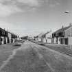
NF75NE 4.01 centred NF 77102 55329 Barracks; Military camp

NF75NE 4.02 centred NF 78033 55338 Barracks; Military Camp

NF75NE 4.03 centred NF 76159 42759 Radar site; Buildings

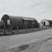
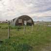
NF75NE 4.04 centred NF 79014 55691 Radar site; Aircraft Hangars

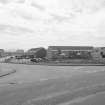
NF75NE 4.05 centred NF 78226 55502 Control tower; Aircraft Hangars

NF75NE 4.06 NF 78260 56184, NF 78351 56331 and NF 78401 56497 Aircraft Hangars

NF75NE 4.07 NF 78910 57036, NF 78933 57248 and NF 78971 56882 Bomb Store

NF75NE 4.08 NF 78969 56553 and NF 79170 56639 Aircraft Hangars

NF75NE 4.09 centred NF 7669 5524 Military Camp

NF75NE 4.10 centred NF 7660 5503 and NF 7630 5508 Military camps

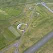
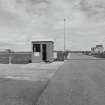
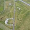
NF75NE 4.11 c.NF 7843 5505 Bunker (Battle HQ).

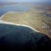
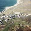
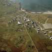
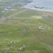
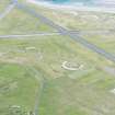
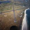
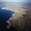
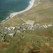
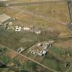
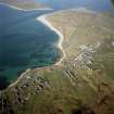
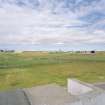
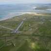
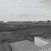
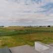
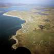
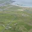
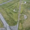
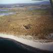
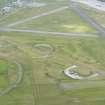
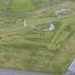
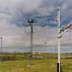
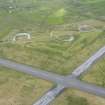
A wartime airfield developed from a pre-war civilian airstrip, known as Balivanich. It consists of three runways of unusual construction using bitumen laid directly on sand.

D J Smith 1983

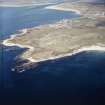
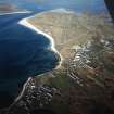
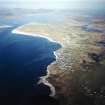
This airfield is situated in an area to the NE of Baile a'Mhaniach.

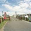
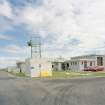
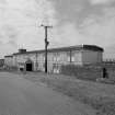
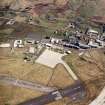
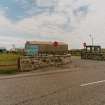
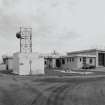
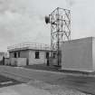
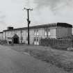
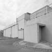
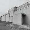
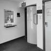
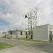
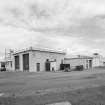
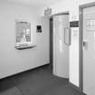
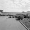
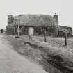
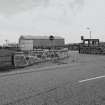
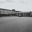
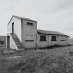
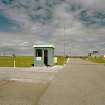
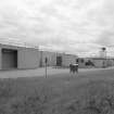
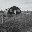
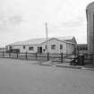
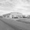
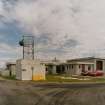
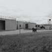
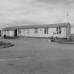
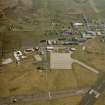
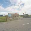
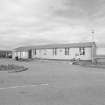
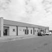
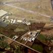
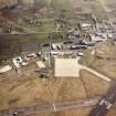
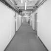
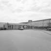
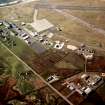
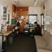
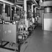
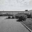
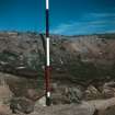
The airfield is still active with many modern buildings interspersed among the WW II structures. The still extant WW II buildings include the Battle HQ, surface shelters and other ancilliary structures.

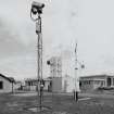
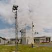
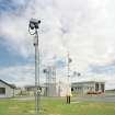
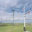
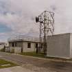
The radar control and reporting centre which linked with the Buchan Radar site during the Cold War period also survives at this airfield.

J Guy 2002; NMRS MS 810/12, 97-100

The complete immediate postwar airfield including the runways, aircraft hangars, bomb store and accommodation camps is visible on vertical air photographs taken in 1946 (CPE/Scot/UK191, 4038-4043, flown 10 October 1946).

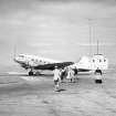
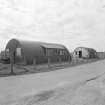
The runways were constructed using a type of construction where bitumen was laid directly on to compacted sand (Smith 1983). The aircraft hangars were half size T2 type, supposedly to minmise the area exposed to the high winds expected on this airfield. All aircraft hangars have now been removed with two being sold in 1949 to Royal Dutch Airlines for re-erection at Schipol Airfield (Smith 1983).

The bomb store (NF75NE 4.07) is situated at An Tom to the N of the runways.

The airfield is now in use as Benbucla Airport and some reconstruction has ocurred in the area around the control tower. The airport and more recent military activity is visible on 1988 air photographs (All Scotland Survey, 04 87 155-157, flown 22 May 1987).

The Luftwaffe target photograph (1941) shows the airfield under construction with the runways half completed and many of the ancilliary buildings incomplete. There is no evidence of the bomb store (NF75NE 4.07) on this image.

Information from RCAHMS (DE), August 2005

Activities

External Reference (18 May 2012)

Mr Macdonald, resident of Benbecula, suggests that the airstrip was not built directly on sand as recorded in some sources. Local residents recall machinery being used to move large amounts of sand prior to laying of a mixture of sand, lime and tar under matting. Once cooled, a tracklayer passed over, followed by a steam roller.

One of the machines used was manufactured by the Barber-Greene company and the steam roller is remembered as having pictures of rearing horses on the rollers. It is also remembered that there were a number of delays as machinery parts had to come from the United States. Later on in construction, permission was granted to manufacture spare parts in England.

The sub-contracters for this work was Limmer and Trinidad.

Information from Mr A Macdonald, Benbecula, via email.

SC 18 May 2012

References

MyCanmore Image Contributions


Contribute an Image

MyCanmore Text Contributions