
Ormiegill


Chambered Cairn (Neolithic), Natural Feature(S) (Period Unknown)
Site Name Ormiegill
Classification Chambered Cairn (Neolithic), Natural Feature(S) (Period Unknown)
Alternative Name(s) Ormiegill South, Wic 201
Canmore ID 9042
Site Number ND34SW 36
NGR ND 33495 42476
NGR Description ND 33495 42476 and ND 3332 4288
Datum OSGB36 - NGR
Permalink http://canmore.org.uk/site/9042


- Council Highland
- Parish Wick
- Former Region Highland
- Former District Caithness
- Former County Caithness
ND34SW 36 3350 4247 and 3332 4288
(ND 3332 4288) Cairns (NR)
(ND 3349 4247) Cairn (NR)
OS 6" map (1960).
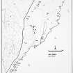
The cairn at ND 3349 4247 has been almost entirely removed, its outline being marked by a low, stony ridge. In the centre are two earthfast stones, some 0.4m high by 1.2m wide by 0.3m, set approximately 3.2m apart, which may be the remains of a chamber.
The two 'cairns' at ND 3332 4288 are natural mounds.
Resurveyed at 1:2500.
Visited by OS (R L) 19 April 1967.
(ND 3350 4247) Cairn (NR) (rems of)
OS 1:10,000 map, (1976)
Grass-covered and ruinous with some erosion, the cairn measures about 10 by 5m.
C E Batey 1981.
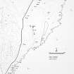
This cairn is on a terrace in an area of rough grazing at 50m OD. It is overlooked by the ridge of the Hill of Ulbster on the W, and overlooks a bog (a drained loch) on the E. The round cairn has been very severely robbed and is now barely 1m high at the maximum. It is grass-covered, and the edge is very indefinite, stone having been spread over an area of about 18m E-W and somewhat more N-S. In its centre are two large almost parallel upright slabs 2.75m apart. The N slab is 1.2m long by 0.35m thick, and the S slab is 1.4m long by 0.4m thick leaning slightly to the S. Both are 0.4m high. The size and disposition of the slabs suggest a portal or divisional slab and a back-slab of a chamber orientated N-S with the back to the S. This cairn is mentioned by Anderson. 'Another large cairn, with two monolithic slabs standing in the centre, was also commenced; but finding that it had been, at some time previously, turned up to the bottom, its further exploration was abandoned as useless' (1866a). He interpreted the remains as a chambered cairn which had been destroyed (1868).
J L Davidson and A S Henshall 1991, visited 1 September 1986.
This chambered cairn is situated immediately E of a rough track that climbs the E flank of the Hill of Ulbster, some 430m N of Mains of Ulbster farmsteading (ND34SW 258). Roughly oval on plan, the grass- and gorse-grown cairn stands on the leading edge of a terrace from which the ground drops sharply to the E. It measures about 21m from N to S by 18m transversely and 1m in height, and two large upright slabs protrude through the cairn material at the centre. Set parallel some 2.7m apart, they rise 0.4m above the turf, the S stone measuring 1.35m in length by 0.43m in thickness, and the N slab 1.2m by 0.35m.
(YARROWS04 732)
Visited by RCAHMS (JRS) 25 August 2004
Project (1980 - 1982)

