
Pricing Change
New pricing for orders of material from this site will come into place shortly. Charges for supply of digital images, digitisation on demand, prints and licensing will be altered.
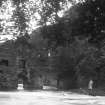
Edinburgh, Cramond, River Almond Walk, Fairafar Mill And Weir


Iron Works (18th Century), Mill (17th Century), Weir (18th Century)
Site Name Edinburgh, Cramond, River Almond Walk, Fairafar Mill And Weir
Classification Iron Works (18th Century), Mill (17th Century), Weir (18th Century)
Alternative Name(s) Fair-a-far Mill; Niddry Mill
Canmore ID 90348
Site Number NT17NE 97
NGR NT 18453 76418
Datum OSGB36 - NGR
Permalink http://canmore.org.uk/site/90348


- Council Edinburgh, City Of
- Parish Edinburgh (Edinburgh, City Of)
- Former Region Lothian
- Former District City Of Edinburgh
- Former County Midlothian
NT17NE 97 18453 76418
Extensive iron works connected with Caddell (sic) & Co in which all old iron is manufactured into maleable bars which is done by means of a prodigious hammer weighing around hundred weight worked by water power for the purpose of which a strong weir is constructed across the river, a small railway from this to Cockle Mill conveys the iron to be shipped in vessels.
Name Book 1852
Now reduced to a shell, this mill, first mentioned in 1676 was originally a waulkmill. There is no evidence that Fairafar Mill was developed for iron-making before 1770. In 1773 the mill was turned into the works forge after the arrival of the Cadells at Cramond Mill (NT17NE 69), where small forgings such as files, plough socs and girdles were made. The mill had been bought by the Smith Wright Work Company to ensure a good flow of water at the lower mill.
The mill would appear to have had one wheel, an illustration by James Stewart of about c1840 shows a large undershot wheel on the S wall of the building. The engraving also shows that cinders and slag were being dumped in the river. The mill is also depicted on Thomas Carfrae's map of 1839 showing the layout of the buildings as they were originally.
The present shell measures 48 by 43.5ft, inside walls 3ft thick, and represents the 'west forge' which had two furnaces with chimney stalks and a tilt hammer. Beside this stood another building, the 'east forge, under which the lead passed, and from which was removed, on its demolition, the inscribed stone built into the remaining wall, BW : IL: 1759. This forge also housed two furnaces and a hammer. Both buildings are shown in a photograph of the 1920's. About 50yds downstream, there was a works gatehouse and the mill buildings included a house for the principal foreman and his family.
There is evidence in 1839 of a tramway or horse-railway between Fairafar Mill and Cramond Mill (Cockle Mill) built to facilitate the transport inwards of coal and iron.
After the Cadells association with the mills ended in the 1860's, iron-milling continued for about another twenty years on a reduced scale, Fairafar was largely demolished in 1935 following a flood.
P Cadell 1973; B Skinner 1965; J P Wood 1794 (1994).
NT 1884 7677 Short length of iron rail, probably part of horse railway used for transport of iron products from Fair-a-Far and Cockle mills (NT17NE 69), visible alongside River Almond walkaway. Line of tramway first shown on Carfrae's 1839 plan of the Lands of Fair-a-Far.
V E Dean 1995.
Watching Brief (1995)
NT 1884 7677
Short length of iron rail, probably part of horse railway used for transport of iron products from Fair-a-Far and Cockle mills (NT17NE 69), visible alongside River Almond walkaway. Line of tramway first shown on Carfrae's 1839 plan of the Lands of Fair-a-Far.
V E Dean 1995.
Watching Brief (4 August 2017 - 6 September 2017)
A programme of archaeological works was required by Green Cat Contracting Limited before the complete demolition of the 20th century Fish Pass associated with a 19th century Weir at Fair-A-Far, Crammond and its replacement with a new one. The works also involved the repair of the damaged N section of the Weir. During these works a detailed record was made of the all structural elements which were to be demolished or repaired. Beneath the Fish Pass earlier 18th or 19th century structural elements were identified which may relate to an elevated cantilevered carriageway associated with the nearby Craigie Quarry and may have been used to convey stone from the quarry for the construction of the Weir. The earlier elements may also have been part of the Weir, acting as an earlier Fish Pass, Spillway or sluice.
Information from Liam McKinstry and Thomas Rees (Rathmell Archaeology)Limited) 5 March 2018. OASIS ID - rathmell1-310719

