|
Photographs and Off-line Digital Images |
WL 3431 |
List C Survey |
List C Survey 1975/6 |
1975 |
Item Level |
|
|
Photographs and Off-line Digital Images |
C 87399 PO |
Records of Sir William Arrol and Company Ltd, civil engineers, Glasgow, Scotland |
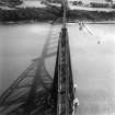
View looking N
n.d. (pre-1952)
Photographed by Francis Caird Inglis, Rock House, Calton Hill, Edinburgh
Acc. No. 1987/2
Filed in Negative store
Sir William Arrol Collection Box 14 |
|
Item Level |
|
 |
On-line Digital Images |
SC 451918 |
Papers of Professor John R Hume, economic and industrial historian, Glasgow, Scotland |
South Queensferry, Hawes Pier, Lighthouse
View from SW, Forth Rail Bridge in background |
5/10/1974 |
Item Level |
|
|
Photographs and Off-line Digital Images |
A 82166 PO |
Papers of Professor John R Hume, economic and industrial historian, Glasgow, Scotland |
South Queensferry, Hawes Pier, Lighthouse
View from SW, Forth Rail Bridge in background |
5/10/1974 |
Item Level |
|
|
Manuscripts |
MS 749/820 |
Papers of Professor John R Hume, economic and industrial historian, Glasgow, Scotland |
J R Hume Industrial/CBA cards. Filed under West Lothian county, Dalmeny parish, Lighthouse. Photograph noted. (See NMRS MS/749 entry for Collection description) |
|
Item Level |
|
|
Photographs and Off-line Digital Images |
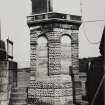
WL 860 |
|
South Queensferry, Hawes Pier, lighthouse.
View from West |
1967 |
Item Level |
|
|
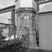
Photographs and Off-line Digital Images |
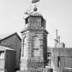
WL 1038 |
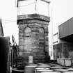
Records of the Scottish National Buildings Record, Edinburgh, Scotland
|
General view of beacon on Hawes Pier, South Queensferry, from East. |
5/1957 |
Item Level |
|
|
All Other |
WLR 1/1 |
|
South Queensferry, Hawes Pier, lighthouse.
Record Sheet with text and pencil sketch. |
1968 |
Item Level |
|
|
All Other |
WLR 1/2 |
|
South Queensferry, Hawes Pier, lighthouse.
Record Sheet with text. |
1967 |
Item Level |
|
|
Manuscripts |
MS 725/138 |
Historic Scotland Archive Project |
Report of coastal assessment survey for Historic Scotland: The Firth of Forth from Dunbar to the border of Fife. (3 volumes)
Revised version with amended text. |
1996 |
Item Level |
|
|
Manuscripts |
MS 2221/05 |
Historic Scotland Archive Project |
Survey archive: List of Vertical Aerial Photographs consulted in the NMRS, from Coastal Assessment Survey, 'The Firth of Forth from Dunbar to the Coast of Fife'. |
1996 |
Item Level |
|
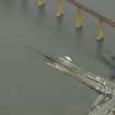 |
On-line Digital Images |
DP 026305 |
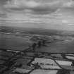
RCAHMS Aerial Photography Digital |
Oblique aerial view centred on the pier, slipway, lifeboat station and beacon with the railway bridge adjacent, taken from the SW. |
21/3/2007 |
Item Level |
|
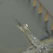 |
On-line Digital Images |
DP 026306 |
RCAHMS Aerial Photography Digital |
Oblique aerial view centred on the pier, slipway, lifeboat station and beacon with the railway bridge adjacent, taken from the S. |
21/3/2007 |
Item Level |
|
 |
On-line Digital Images |
DP 026307 |
RCAHMS Aerial Photography Digital |
Oblique aerial view centred on the pier, slipway, lifeboat station and beacon, taken from the SW. |
21/3/2007 |
Item Level |
|
 |
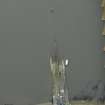
On-line Digital Images |
SC 1268931 |
Records of Aerofilms Ltd, aerial photographers, Bristol, England |
Forth Rail Bridge, Firth of Forth. Oblique aerial photograph taken facing north. This image has been produced from a damaged negative. |
24/4/1948 |
Item Level |
|
 |
On-line Digital Images |
SC 1314755 |
Records of Aerofilms Ltd, aerial photographers, Bristol, England |
Forth Rail Bridge, Firth of Forth. Oblique aerial photograph taken facing north. This image has been produced from a print. |
24/4/1948 |
Item Level |
|
 |
On-line Digital Images |
SC 1314875 |
Records of Aerofilms Ltd, aerial photographers, Bristol, England |
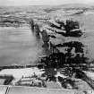
Firth of Forth, general view, showing Dalmeny and Forth Rail Bridge. Oblique aerial photograph taken facing north. This image has been produced from a print. |
21/9/1948 |
Item Level |
|
 |
On-line Digital Images |
SC 1647104 |
List C Survey |
List C Survey 1975/6 |
1975 |
Item Level |
|
 |
On-line Digital Images |
SC 1314961 |
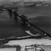
Records of Aerofilms Ltd, aerial photographers, Bristol, England |
Forth Rail Bridge and Hawes Pier, South Queensferry. Oblique aerial photograph taken facing south. This image has been produced from a print. |
25/9/1948 |
Item Level |
|
|
Photographs and Off-line Digital Images |
DP 298279 |
Survey of a Private Collection: An album of photographs of the construction of the Forth Bridge. |
View from E of event beside Hawes Pier possibly in connection with the construction of the Forth Bridge |
c. 1886 |
Item Level |
|
 |
On-line Digital Images |
SC 2180983 |
Records of the Scottish National Buildings Record, Edinburgh, Scotland
|
General view of beacon on Hawes Pier, South Queensferry, from East. |
5/1957 |
Item Level |
|
 |
On-line Digital Images |
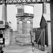
SC 2659965 |
|
South Queensferry, Hawes Pier, lighthouse.
View from West |
1967 |
Item Level |
|
 |
On-line Digital Images |
SC 2720352 |
|
South Queensferry, Hawes Pier, lighthouse.
View from West |
1967 |
Item Level |
|
 |
On-line Digital Images |
SC 2732590 |
Records of the Ordnance Survey, Southampton, Hampshire, England |
Queensferry, Hawes Pier, NT17NW 111, Ordnance Survey index card, Recto |
c. 1958 |
Item Level |
|


