
Pricing Change
New pricing for orders of material from this site will come into place shortly. Charges for supply of digital images, digitisation on demand, prints and licensing will be altered.
Heatherquoy


Broch (Iron Age)(Possible), Mound (Period Unassigned)
Site Name Heatherquoy
Classification Broch (Iron Age)(Possible), Mound (Period Unassigned)
Alternative Name(s) Wic 205; Ulbster 2; Field
Canmore ID 9030
Site Number ND34SW 27
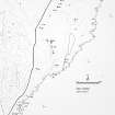
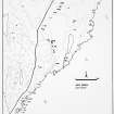
NGR ND 32713 41714
Datum OSGB36 - NGR
Permalink http://canmore.org.uk/site/9030


- Council Highland
- Parish Wick
- Former Region Highland
- Former District Caithness
- Former County Caithness
ND34SW 27 3271 4171.
(ND 3271 4171) Mound (NR)
OS 1:10,000 map, (1976)
A grassy knoll, the character of which is not obvious. It measures 110ft N-S by 95ft transversely and 8ft in maximum height, with no depression in the summit.
RCAHMS 1911.
A low mound of indefinite shape, as described by the RCAHMS, situated on a low ridge. Whether it is an antiquity or not cannot be ascertained without excavation.
Visited by OS (N K B), 27 April 1967.
A natural mound.
C Batey 1981.
This large, grass-grown mound, which is possibly the remains of a broch, is situated at the S end of a strip of waste ground 70m S of the house at Field. Roughly oval on plan, the base of the mound on the W and S has clearly been truncated by cultivation and it now measures 32.5m from NNE to SSW by 26.5m transversely and up to 3.5m in height. A small area of erosion on the S side of the mound has revealed what may be drystone walling.
The mound is described in the Ordnance Survey Name Book as 'a green hillock near the farm houses of Field. It has the usual resemblance of a Pict's House'.
(YARROWS04 741)
Visited by RCAHMS (JRS), 25 August 2004.
OS Name Book.
Project (1980 - 1982)
Publication Account (2007)
ND34 13 ULBSTER 2 (‘Heatherquoy’)
ND/3271 4171
Possible broch in Wick, Caithness, consisting of a grassy knoll measuring 33.6m (110ft) by 29.0m (95ft) transversely and with no depression on the summit. There is no real evidence that it is an ancient structure and only the fact that such mounds often contain brochs warrants the inclusion of the site here.
Sources: 1. NMRS site ND 34 SW 27: 2. RCAHMS 1911b, 190, no. 586.
E W MacKie 2007

