
Broughwhin


Hut(S) (Period Unassigned)
Site Name Broughwhin
Classification Hut(S) (Period Unassigned)
Alternative Name(s) Garrywhin; Warehouse
Canmore ID 9026
Site Number ND34SW 257
NGR ND 31197 41228
NGR Description ND 31197 41228 and ND 31199 41233
Datum OSGB36 - NGR
Permalink http://canmore.org.uk/site/9026


- Council Highland
- Parish Wick
- Former Region Highland
- Former District Caithness
- Former County Caithness
ND34SW 257 31197 41228 & 31199 41233
Huts.
Visited by OS (NKB) 27 April 1967.
(May equate ND34SW 17 Hut Circles).
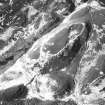
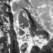
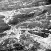
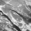
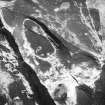
The remains of two huts are situated on top of a large grass-grown rise between the N end of the pond at Broughwhin and the Garrywhin fort (ND34SW 3). Both huts have been reduced to little more than low subrectangular mounds, the northern measuring 5m from E to W by 3.5m transversely, and the southern 4.8m from ESE to WNW by 2.6m transversely. From the SE corner of the latter, a boulder wall extends downhill towards the pond.
(YARROWS04 72-3)
Visited by RCAHMS (ARG, ATW) 16 June 2004.

