
Pricing Change
New pricing for orders of material from this site will come into place shortly. Charges for supply of digital images, digitisation on demand, prints and licensing will be altered.
Cairnryan Military Railway


Railway (20th Century)
Site Name Cairnryan Military Railway
Classification Railway (20th Century)
Canmore ID 90258
Site Number NX06SE 94
NGR NX 0850 6000
NGR Description From NX 0850 6000 to NX 0787 6500
Datum OSGB36 - NGR
Permalink http://canmore.org.uk/site/90258


- Council Dumfries And Galloway
- Parish Inch
- Former Region Dumfries And Galloway
- Former District Wigtown
- Former County Wigtownshire
NX06SE 94.00 0850 6000 to 0787 6500
See also NX06NE 11.00
NX06SE 94.01 Centred NX 0830 6372 Workshops; Slipway; Nissen Huts
NX06SE 94.02 NX 0775 6025 to NX 0790 6105 Railway
NX06SE 94.03 NX 0794 6111 Building
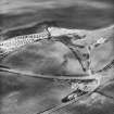
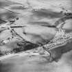
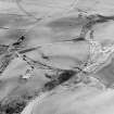
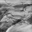
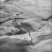
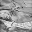
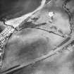
Cairnryan Military Railway was constructed between November 1941 and June 1942. Included are the workshops at Innermessan (NX06SE 94.01) and an Army temporary railway (NX06SE 94.02) constructed to allow tipping to make embankments either side of the London Road bridge to proceed simultaneously.
Additional transfer siding space was built at Cairnryan Junction, where the line connected with the main line to Stranraer and the railway was fully signalled throughout, with signal boxes, workshops, engine sheds, double track in certain sections and wooden platformed stations or halts at London Road, Innermessan, Leffnoll and Cairnryan.
M Christensen 1995 (two parts)

