
Pricing Change
New pricing for orders of material from this site will come into place shortly. Charges for supply of digital images, digitisation on demand, prints and licensing will be altered.
Cairnryan Harbour, Cairnryan Military Railway


Railway (20th Century)
Site Name Cairnryan Harbour, Cairnryan Military Railway
Classification Railway (20th Century)
Canmore ID 90254
Site Number NX06NE 11.03
NGR NX 0786 6500
NGR Description From NX 0786 6500 to NX 0592 7000
Datum OSGB36 - NGR
Permalink http://canmore.org.uk/site/90254


- Council Dumfries And Galloway
- Parish Inch
- Former Region Dumfries And Galloway
- Former District Wigtown
- Former County Wigtownshire
NX06NE 11.03 From 0786 6500 to 0592 7000
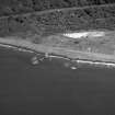
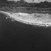
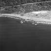
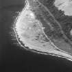
The Cairnryan Military Railway was constructed to facilitate the building of the miltary harbours at Cairnryan (NX06NE 11.00) and the Lighterage Wharf (NX06NE 11.01). Construction took place between November 1941 and June 1942. Running from Cairnryan Junction (NX06SE 94.00) to Cairnryan, a distance of some six miles, it required the building of several areas of railway sidings, transit sheds, railway engine sheds, stations and the diversion of the road at Cairn Point from its former course close to the lighthouse. Additional work was required on the main railways leading to the junction at Aird (Cairnryan Junction NX06SE 94.00). In May 1942 a passenger service was introduced in addition to the works trains, to allow off-duty personnel to get to Stranraer for recreation. The railway was fully signalled and though few earthworks were required, several bridges were needed on the southern section (NX06SE 94.00).
M Christensen 1995 (two parts).
The whole length of the railway is visible on vertical air photographs (106G/Scot/UK 3135-3140 and 4129-4130, flown 9 November 1945), which show that at this date it was still in use.
Information from RCAHMS (DE), March 2006

