
Watenan


Broch (Iron Age)(Possible), Quarry(S) (Period Unassigned)
Site Name Watenan
Classification Broch (Iron Age)(Possible), Quarry(S) (Period Unassigned)
Alternative Name(s) Watenan South
Canmore ID 8994
Site Number ND34SW 11
NGR ND 31716 41147
Datum OSGB36 - NGR
Permalink http://canmore.org.uk/site/8994


- Council Highland
- Parish Wick
- Former Region Highland
- Former District Caithness
- Former County Caithness
ND34SW 11 31716 41147.
(ND 3171 4115) Broch (NR)
OS 1:10,000 map, (1976)
A small fort, the dimensions of which (but for the absence of debris) would suggest a broch, is situated on the crest of a rocky ridge. It comprises a circular area, 27ft in diameter, within a wall some 12ft thick and 3 to 4ft high, possibly entered from the SE, and is set eccentrically within another wall some 12 to 18ft thick which surrounds it at varying distances up to 30ft.
'From the E end of the N front a bank or wall apparently connects the two lines of circumvallation. At the N extremity the outer wall presents a scarp about 10ft in height, with a shallow ditch some 10ft in width at the base of it. On the S this wall is less prominent... the ditch is visible at this end also.
RCAHMS 1911.
The turf-covered remains of a broch (not a fort as claimed above) within an outer defensive work, as described by the RCAHMS.
One course of heavy stone walling protrudes through the turf in the S of the broch for a short distance, and a slight depression around the top of the rampart, together with a more lush growth of turf, indicates a mural passage. The entrance through the outer defences is in the SW. The absence of debris is probably due to later robbing.
Resurveyed at 1:2500.
Visited by OS (N K B) 27 April 1967.
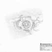
This broch is situated on the summit of an un-named rocky hill about 120m SSW of Watenan farmsteading. The broch has been heavily robbed and now forms a grass-grown mound measuring up to 20m in diameter by 1.1m in height, with a dished interior 8.8m in diameter by up to 1m in depth. There is also evidence that the site has been excavated; the corners of shallow trenches are clearly visible and where structural features, such as intra-mural galleries, have been found, they seem to have been partly cleared out. Little trace of the inner wall-face is visible, but the entrance appears to have been on the SE and there are intra-mural features on the SW, NW and NNE.
The broch lies within the remains of a wall and ditch, which is best preserved on the N, where they cut off access from a gentle ascent. Here the grass-grown wall forms a bank up to 3.8m in thickness and 1.7m in external height and the external ditch is 6m in breadth by 1m in depth. This ditch runs on to the natural slope at its W end and on the E it seems to have a rounded terminal, although there is no corresponding gap in the rampart. On the S, the bank measures about 4m in thickness by 1.2m in external height; at its E end it has been partly destroyed by quarrying and all along its length it bears the scars of small-scale robbing. This bank is accompanied by an external ditch, which is considerably narrower and shallower than its counterpart on the N. Further, both ends of the ditch have been destroyed by quarrying (YARROWS04 449, 450). Elsewhere, to the E and W of the broch respectively, the rampart has been reduced to little more than a stony spread, but two short runs of large boulders (the largest measuring 1.1m in length and 0.5m in height) are visible in up to two courses. These are situated considerably down slope and could only have functioned as the footings of a wall carrying a considerable batter.
In addition to the quarries already mentioned, there is a series of small pits along the crest of the E side of the hill.
(YARROWS04 038, 449, 450)
Visited by RCAHMS (JRS) 26 May 2004
Measured Survey (26 May 2004)
RCAHMS surveyed the broch at Watenan on 26 May 2004 with plane table and self-reducing alidade producing a plan at a scale of 1:250.
Publication Account (2007)
ND34 7 LOCH WATENAN (‘Watenan’)
ND/3171 4114
Probable broch on a rocky ridge in Wick, Caithness, consisting of the remains of a circular stone building with a wall 3.6m (12ft) thick, standing 90-120cm high and enclosing a court 8.24m (27ft) in diameter. There was a suggestion of an entrance in the south-east in 1910 but the absence of debris led to doubts about the identification of the site as a broch [2]. However one course of a heavy stone wall was seen in 1967 [1]. An outer wall 3.66-5.49m (12-18ft) thick surrounds the circular building at a distance of up to 9m (30ft). There are traces of an external ditch on the north.
Sources: 1. NMRS site no. ND 34 SW 11: 2. RCAHMS 1911b, 164, no. 526.
ND34 16 WATENAN SOUTH ('Loch Watenan 2') ND/317411*
This possible broch in Wick, Caith-ness, is another example of a ruined building at the centre of a complex of other features [3]. The site stands on top of a natural crag, with its rocky face towards the east, among farmland. The circular central earthwork shows stone facing on its outer side and might be a ruined broch, although the small amount of visible rubble made the Commission doubt that it was [2]. The enclosed area is 8m in diameter and linear grassy depressions around this might be intra-mural galleries [3]. There is a suggestion of an entrance on the east side in the form of two facing stones. To the north-west, west and south are outer defences consisting of an inner bank with an external ditch; the stone-face inner side of the bank forms two revetted courtyards to the north and south of the broch, and there are possible outbuildings between the inner and outer ramparts on the south-east side [3].
Sources: 1. NMRS site no. ND 34 SW 11: 2. RCAHMS 1911b, 164, no. 526: 3. Mercer 1985, 104, no. WAR 177 and fig. 61.
E W MacKie 2007

