
Kirkdale


Farmstead (Period Unassigned), Stable(S) (Period Unassigned)
Site Name Kirkdale
Classification Farmstead (Period Unassigned), Stable(S) (Period Unassigned)
Alternative Name(s) Stables
Canmore ID 89881
Site Number NX55SW 64
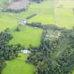
NGR NX 51284 53605
Datum OSGB36 - NGR
Permalink http://canmore.org.uk/site/89881


- Council Dumfries And Galloway
- Parish Kirkmabreck
- Former Region Dumfries And Galloway
- Former District Wigtown
- Former County Kirkcudbrightshire
Photographic Survey (June 1964)
Photographic survey of Kirkdale staeding and Slaughterhouse, Kirkcudbrightshire, by the Scottish National Buildings Record in June 1964.
Photographic Survey (June 1964)
Photographic survey by the Scottish National Buildings Record in June 1964.
Desk Based Assessment (27 June 2000)
NX55SW 101 5129 5359
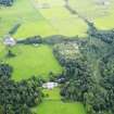
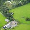
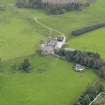
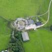
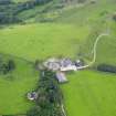
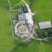
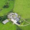
A courtyard farmstead, comprising one large octagonal roofed building, and two small unroofed buildings eachannotated 'Ruin' is depicted on the 1st edition of the OS 6-inch map (Kirkcudbrightshire 1853, sheet 48). The octagonal shaped building with a large outshot to the N is shown on the current edition of the OS 1:10000 map (1982).
Information from RCAHMS (AKK) 27 June 2000.
Note (21 June 2012)
For the slaughterhouse at Kirkdale farmstead, see NX55SW 113.
Information from RCAHMS (LMcC) 21 June 2012

