
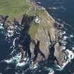
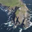
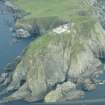
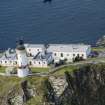
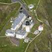
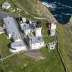
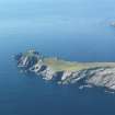
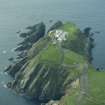
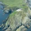
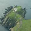
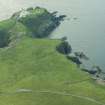
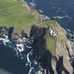
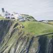
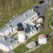
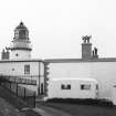
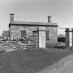
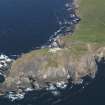
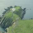
Sumburgh Head Lighthouse


Lighthouse (19th Century)
Site Name Sumburgh Head Lighthouse
Classification Lighthouse (19th Century)
Alternative Name(s) Sumburgh Lighthouse
Canmore ID 898
Site Number HU40NW 3
NGR HU 40723 07872
Datum OSGB36 - NGR
Permalink http://canmore.org.uk/site/898


- Council Shetland Islands
- Parish Dunrossness
- Former Region Shetland Islands Area
- Former District Shetland
- Former County Shetland
HU40NW 3.00 40723 07872
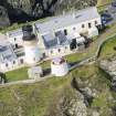
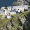
HU40NW 3.01 40711 07871 West Keeper's House
HU40NW 3.02 40729 07883 East Keeper's House
HU40NW 3.03 40726 07905 Engine House
HU40NW 3.04 40761 07925 Foghorn
For (associated) jetty and store at Grutness Voe (HU 4051 1011), see HU41SW 9.
For Sumburgh radar station (HU 4072 0788), see HU40NW 4.
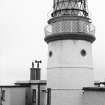
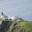
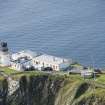
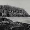
(Location cited as HU 407 079). Sumburgh Head Lighthouse, completed c. 1830 by engineer Robert Stevenson. A short circular-section tower with blocks of two-storey keepers' houses.
J R Hume 1977.
Construction (January 1819 - 1821)
Light established in 1821.
K Allardyce and K M Hood 1986
Publication Account (1997)
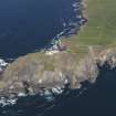
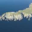
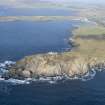
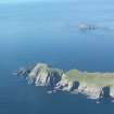
'It is proposed to have a light on Sumburgh-head, which is the first land made by vessels coming from the eastward; Fitful-head is higher, but it is to the west, from which quarter few vessels come.' Thus wrote Sir Walter Scott in his journal in 1814, and a lighthouse was duly built on 'this tremendous cape' by Robert Stevenson six years later. The great height of the headland itself meant that only a short tower was needed, and it was built with three floors rising to a lantern cupola (later replaced with a modern lantern). The design of the original lantern and the elegant keepers' quarters can be appreciated from the drawing showing the landward elevation. Part of the keepers' accommodation is now used by the Royal Society for the Protection of Birds, for Sumburgh Head is home to one of Shetland's largest colonies of puffins.
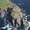
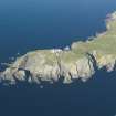
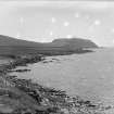
Just off Sumburgh Head is the notorious roost, a stretch of water so turbulent that its breaking waves can be heard even on calm days. This is a tidal stream, where opposing tidal forces from east and west meet. A fine jetty was constructed on Grutness Voe to serve the new lighthouse (HU 405 100; HU41SW 9), and it is still used by the ferry for Fair Isle.
There was a large prehistoric promontory fort on Sumburgh Head (HU40NW 1). It was mostly destroyed when the lighthouse complex and its approach road were built, but the remains of one of the earthen ramparts can be seen alongside the modern road at HU 406080. This may well have been the 'borg' or fort that inspired the name Sumburgh.
Information from ‘Exploring Scotland’s Heritage: Shetland’, (1997).
Magnetometry (25 April 2011 - 26 April 2011)
HU 4070 0785 A gradiometer survey was carried out 25–26 April 2011 in advance of a proposed refurbishment of the lighthouse. The survey did not locate any obvious anomalies of archaeological interest, although one response may date from the First or Second World War.
Archive: ORCA Geophysics
Funder: Shetland Amenity Trust
ORCA Geophysics, 2011
Watching Brief (December 2011)
HU 40723 07872 Since December 2011 a programme of archaeological work has been ongoing at Sumburgh Head, as part of a restoration and adaptive reuse project. This project includes the refurbishment of the 19th- and early 20th-century lighthouse buildings, the creation of a marine life centre and a new education room at one of the most accessible bird colonies in the United Kingdom. The cultural heritage forms a significant interpretive element of the project with the site of an Iron Age fort and surviving WW2 radar station located within the lighthouse complex. The archaeological monitoring has consisted of evaluation trenches, in advance of groundwork, complemented by watching briefs.
The site of an Iron Age fort at Sumburgh Head features on a 17th-century map and a written description was compiled during the late 18th century. The earthwork ramparts survive c150m to the N of the lighthouse and were annotated on the 1st Edition OS map of the area. An evaluation was undertaken on the site of the fort ramparts in advance of the construction of a new water pump house. No structural remains were identified, although three historic ground surfaces were recorded, representing historic remodeling of the area and soil micromorphology samples were taken from these surfaces. In addition, five evaluation trenches were dug in the W field in advance of the installation of a ground source heat pump. No archaeological finds or features were recorded in this steeply sloping field.
Watching briefs have been undertaken in association with new car parks, cabling and associated infrastructure works. In the area adjacent to the fog horn a 20th-century brick-lined pit was discovered, which may have been an ammunition store for a wartime Lewis Gun position. To the S of the East Pavilion a mass concrete blast wall was found in a recumbent position and this viewed in association with documentary material, indicates an air raid shelter existed within the lighthouse complex. Machine excavations for a new stone dyke in the vicinity of the Iron Age rampart and wartime Nissen hut foundations led to the discovery of several .303 bullet casings, a button and possible part of a cap badge, relating to the wartime usage of the site.
Archive: Shetland Amenity Trust. Report: Shetland Amenity Trust and RCAHMS (intended)
Funder: Shetland Amenity Trust
Chris Dyer, Shetland Amenity Trust, 2013
(Source: DES)

