
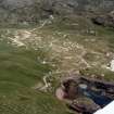
Clachtoll


Township (Period Unassigned)
Site Name Clachtoll
Classification Township (Period Unassigned)
Canmore ID 89508
Site Number NC02NW 14
NGR NC 041 274
NGR Description centred on NC 041 274
Datum OSGB36 - NGR
Permalink http://canmore.org.uk/site/89508


- Council Highland
- Parish Assynt
- Former Region Highland
- Former District Sutherland
- Former County Sutherland
NC02NW 14.00 centred on 041 274
NC02NW 14.01 NC 0477 2663 Horizontal Mill
A township comprising fifty-six roofed and eleven unroofed buildings is depicted on the 1st edition of the OS 6-inch map (Sutherland 1878, sheet lviii). In the N of the township there are what may be the beginnings of the laying out of plots or crofts.
Thirty roofed and twenty-six unroofed buildings are shown on the current edition of the OS 1:10,000 map (1971).
Information from RCAHMS (SAH) 4 September 1995

