
Pricing Change
New pricing for orders of material from this site will come into place shortly. Charges for supply of digital images, digitisation on demand, prints and licensing will be altered.
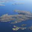
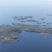
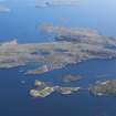
Tanera More, Garadheancal


Township (Period Unassigned)
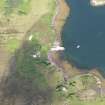
Site Name Tanera More, Garadheancal
Classification Township (Period Unassigned)
Canmore ID 89483
Site Number NB90NE 5
NGR NB 994 070
NGR Description Centred NB 994 070
Datum OSGB36 - NGR
Permalink http://canmore.org.uk/site/89483


- Council Highland
- Parish Lochbroom
- Former Region Highland
- Former District Ross And Cromarty
- Former County Ross And Cromarty
NB90NE 5 centred 994 070
A township comprising fifteen roofed and three unroofed buildings is depicted on the 1st edition of the OS 6-inch map (Cromartyshire 1881, sheet iiiA). Six roofed and eight unroofed buildings, and a sheepfold of three compartments are shown on the current edition of the OS 1:10560 map (1969).
Information from RCAHMS (SAH) 25 September 1995
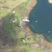
An area of small cairns within a drystone dyke, a short stretch of stone revetment and a 50m stretch of dyke, all within the boundary of Garadheancal township, were recorded during a pre-afforestation survey by Headland Archaeology (NMRS MS 899/80, nos.6-9). The buildings of the township lie to the N of the area designated for planting and were not recorded during the survey.
L Baker and C Moloney (Headland Archaeology) 24 April 1998; NMRS MS 899/80, nos.6-9
Sites recorded during a short-notice pre-afforestation survey was undertaken of Tanera More, one of the Summer Isles off the coast of the mainland opposite Achiltibuie.
NB 9937 0699 Clearance Cairns
NB 9935 0696 Walls and bank.
NB 9963 0681 Stone revetment.
NB 996 066 Dyke.
Sponsor: Historic Scotland
L Baker 1998

