
Shearerston


Building(S) (Period Unassigned)
Site Name Shearerston
Classification Building(S) (Period Unassigned)
Alternative Name(s) Shearerstown
Canmore ID 89098
Site Number NN91NW 98
NGR NN 9197 1832
Datum OSGB36 - NGR
Permalink http://canmore.org.uk/site/89098


- Council Perth And Kinross
- Parish Trinity Gask
- Former Region Tayside
- Former District Perth And Kinross
- Former County Perthshire
NN91NW 98 9197 1832
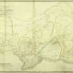
Several buildings are depicted (and identified as Shearerstown) at this location on a map of Innerpeffray estate surveyed by William Keir and dated 1765. The site now lies in an improved field and there were no identifiable remains at the date of visit.
Visited by RCAHMS (ARG, IF), 22 November 1995.
NMRS B78742.

