
Inner Sinni Geo


Farmstead (Period Unassigned)
Site Name Inner Sinni Geo
Classification Farmstead (Period Unassigned)
Alternative Name(s) Dun 005
Canmore ID 8900
Site Number ND27SW 25
NGR ND 2189 7456
Datum OSGB36 - NGR
Permalink http://canmore.org.uk/site/8900


- Council Highland
- Parish Dunnet
- Former Region Highland
- Former District Caithness
- Former County Caithness
ND27SW 25 2189 7456.
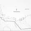
A modern crofting settlement comprising four structures, a stone-lined cutting into the N bank of the stream, with a millstone present, and various associated boundaries. Located to the W and S of the stream at the sea-mouth, it is now a very wet site with marsh and reeds partially surrounding the buildings. The walls are mainly grass-covered although some stonework is visible. The buildings are aligned roughly E-W and face S.
C E Batey 1982.
A long-house associated with walls and a bridge. The long-house('a' on plan) is grass-covered, 18m E-W by 4m by 0.5m high, divided internally. Another possible structure is attached to a wall running to NW. A wall ('b' on plan), at least 100m long, very tumbled and grass-covered froms the perimeter of the farms tead. The possible bridge ('c' on plan) consists of tumbled squared stones at the stream. A millstone lies slightly downstream. A structure('d' on plan) of upr ight stone slabs measures 10m E-W by 3m by 0.5m high. An outbuilding 4 by 3m is attached to the N.
R J Mercer 1981.
A farmstead comprising two unroofed buildings, both attached to lengths of field wall, is depicted on the 1st edition of the OS 6-inch map (Caithness 1876, sheet i), but it is not shown on the current edition of the OS 1:10,000 map (1976).
Information from RCAHMS (SAH) 16 January 1996
Project (1980 - 1982)
Field Visit (1982)
A modern crofting settlement comprising four structures, a stone-lined cutting into the N bank of the stream, with a millstone present, and various associated boundaries. Located to the W and S of the stream at the sea-mouth, it is now a very wet site with marsh and reeds partially surrounding the buildings. The walls are mainly grass-covered although some stonework is visible. The buildings are aligned roughly E-W and face S.
C E Batey 1982.

