
Scheduled Maintenance
Please be advised that this website will undergo scheduled maintenance on the following dates: •
Tuesday 3rd December 11:00-15:00
During these times, some services may be temporarily unavailable. We apologise for any inconvenience this may cause.
Beorgs Of Uyea


Quarry (Period Unassigned), Stone Axe Factory (Neolithic) - (Bronze Age)
Site Name Beorgs Of Uyea
Classification Quarry (Period Unassigned), Stone Axe Factory (Neolithic) - (Bronze Age)
Alternative Name(s) Mill Loch
Canmore ID 890
Site Number HU39SW 2
NGR HU 3269 9006
NGR Description Area around (including up to HU 326 902)
Datum OSGB36 - NGR
Permalink http://canmore.org.uk/site/890


- Council Shetland Islands
- Parish Northmavine
- Former Region Shetland Islands Area
- Former District Shetland
- Former County Shetland
HU39SW 2 3269 9006
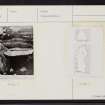
HU 327 901. A gallery which could well have been a pre- historic workshop for the production of stone tools was found and examined by Scott in 1942 and visited by Calder in 1949.
The gallery had been constructed as a trench with one side formed by an intrusive dyke of quartz-felspar-porphyry, and the opposite side and ends of dry-stone masonry, the whole being sunk just below ground level and covered by lintel stones, most of which had been displaced but through which must have been the original access.
Inside, the space measured almsot 10ft long by 2ft 2 ins to 3ft 10 ins wide, and 3ft to 3ft 9 ins high, above a layer of rock chippings 4 to 6 ins in depth which had all the appearance of waste flakes and among which were found a stone anvil, hammer-stones and cores. (The anvil and speciments of the hammers, cores and flakes have passed to the National Museum of Antiquities of Scotland [NMAS]. The dyke is formed of rock peculiar to this area and neolithic and other implements of this and spherulitic felsite, peculiar to the Beorgs of Uyea, have been found throughout Shetland. P R Ritchie (P R Ritchie and S Piggott 1968) states that the rock of the Beorgs of Uyea is not unique in Britain.
L G Scott and C S T Calder 1954
Situated at HU 3266 9007, this 'working gallery' is generally as described above.
Surveyed at 1:10,000.
Visited by OS(RL) 20th May 1969.
(Name: HU 3266 9007) Neolithic Axe Factory & Quarry (NR)
OS 1:10,000 map 1971.
Six complete axe 'rough-outs' of riebeckite felsite were recovered during examination of this site. A large end scraper of the same rock was also discovered.
B Beveridge 1973
One of the 'rough-outs' found by Beveridge is in Cambridge University Museum of Archaeology and Ethnology (Z. 27235).
(Undated) information in Museum Accessions Register.
Ground Survey (September 2011)
HU 326 900 (Beorgs of Uyea) and HU 316 848 (Midfield) As part of ongoing preparations for a future research project – Neolithic Felsite Quarrying in North Roe, Shetland selected areas of North Roe were inspected during September 2011. Investigations in 2010 (DES 2010, 159) had suggested that it is possible to clearly distinguish between workshops relating to the production of axeheads and Shetland knives, and one of the aims of this year’s evaluation was to identify workshops, or clusters of workshops, which might be suitable for later detailed examination and excavation. The purpose of this future work should be to shed light on: 1) felsite quarrying technology and organization; 2) felsite blank, preform and tool technology and organization; 3) felsite exchange within North Roe/Shetland, and beyond; 4) dating the prehistoric exploitation of felsite; and 5) cosmology.
As previous years’ archaeological activity in North Roe (DES 2006–7 and 2010) had shown that felsite dykes in the central parts of the peninsula may have been prospected by prehistoric people, but appeared not to have been exploited in an organized manner, the team focused on selected locations on the Beorgs of Uyea ridge (northern North Roe) and along the elongated summit of Midfield (southern North Roe). Scrutiny of axehead and knife rough-outs and production waste, as well as the different types of felsite available in the selected areas, indicates that axeheads and Shetland knives were manufactured in both locations. However, it was also possible to characterize the two areas in terms of their potential for archaeological investigation. The Beorgs of Uyea, for example, is defined by extensive exploitation, probably over a prolonged period of time, and the deposits of quarrying waste has a clear palimpsest appearance. In contrast, the Midfield summit, or ridge, is characterized by the presence of many discrete, probably single-event, workshops and clusters of workshops.
At Midfield, it was possible to define two main areas of activity, associated with two parallel felsite dykes. Midfield 1 (western dyke) is characterized by two main quarry pits and one main large workshop, probably representing repeated exploitation (although not to a degree comparable to that seen at the Beorgs), relating to combined axehead and knife production. Midfield 2 (eastern dyke), is characterized by four or five quarry pits along a felsite outcrop, with discrete, probably single-event workshops, located on either side of the dyke. The latter dyke follows the landscape contours, and workshops defined by coarse waste from axehead production were found on the E (downslope) side of the dyke, whereas workshops defined by finer waste from knife production were found on the W (upslope) side of the dyke. The Midfield 2 quarry pits and workshops provide a potential initial focus of detailed analysis, as the understanding of these more discrete activity areas may allow areas with palimpsest character to be disentangled.
It was suggested that a first season of fieldwork should concentrate on the mapping of felsite dykes, workshops and associated features in North Roe in general, as well as more detailed mapping of the felsite dyke, quarry pits and workshops at Midfield 2. Other activities relating to the project includes spot-checking in the field of felsite dykes on Muckle Roe, Delting, as it is not certain that only the North Roe Riebeckite felsite was exploited in prehistory, and the collection of raw material samples from these dykes. Axeheads and Shetland knives in felsite in museum collections are also being listed and their find locations mapped, to allow future discussion of the dissemination of these artefacts from North Roe.
Lithic Research/ University of Bradford, University College Dublin, 2011
Field Visit (May 2012)
HU 326 900 (Beorgs of Uyea) and HU 316 848 (Midfield) As part of ongoing preparations for a future research project – Neolithic Felsite Quarrying in North Roe – selected areas of North Roe were inspected during May 2012. The purpose of this future work should be to shed light on: 1) felsite quarrying technology and organisation; 2) felsite blank, preform and tool technology and organisation; 3) felsite exchange within North Roe/Shetland, and beyond; 4) dating the prehistoric exploitation of felsite; and 5) cosmology.
The purpose of this year’s visit was to gather evidence for the manufacture of stone tools using rock quarried from a suite of felsite and other dykes, particularly in the Beorgs of Uyea and Midfield areas. The particular focus was to set petrographic evidence in a framework of geomorphological, geological and archaeological evidence in the field, in order to evaluate the potential for differentiation between products from archaeological sites and geological outcrops.
The work had two sets of results: 1) providing answers to the questions defined prior to the survey (above), and 2) as a by-product of the geological work, finding and defining new archaeological locations in the Midfield area. Following geological characterization of the inspected felsite outcrops and the collected hand samples, it was possible to preliminarily conclude that it should be possible to link individual felsite artefacts to specific geological outcrops or, at least, limited suites of dykes. This is of great importance to future discussions of the distribution of felsite artefacts across Shetland (felsite was probably not ‘exported’ out of the Shetland archipelago), felsite exchange, and social organisation within the island group.
As mentioned in DES 2011 (173) two clusters of felsite workshops are known on Midfield’s eastern flank, both associated with groups of quarry pits. This year, another group of quarry pits was located, this time on the northern flanks of Midfield, towards Ronas Hill. This site (Midfield 3) needs further attention before it is possible to say anything about specific activities, workshops, or the type of artefacts produced. To access the Midfield sites, it was necessary to cross Uyea Scord from Collafirth Hill. When crossing this plateau, two small concentrations of artefacts were noticed, and the finds collected. The composition of one assemblage was c1:10 quartz to felsite flakes, whereas the other had the opposite composition. The important points regarding these two collections are: 1) that there is generally no quartz near the quarries themselves, and 2) that the recovered felsite flakes are small and fine, possibly relating to what Vemming Hansen and Madsen (1983) termed final shaping, in contrast to the production of rough-outs and preforms, which took place at the quarry workshops. This possible spatial separation of the different stages of the reduction of felsite axeheads needs further investigation, and the plateau of Scord of Uyea should be surveyed in greater detail.
Fieldwork in the Midfield area is planned for Spring/Summer 2013. The principal investigator of this work is Professor Gabriel Cooney, University College Dublin.
Archive: RCAHMS and/or Shetland Amenity Trust (intended)
Torben Bjarke Ballin, Lithic Research/University of Bradford
Vin Davis, Implement Petrology Group
2012
Field Visit (June 2013 - July 2013)
HU 326 900 (Beorgs of Uyea) and HU 327 850 (Grut Wells) Building on previous years’ work in North Roe led by Ballin (DES 2013, 167-8) the first season of the North Roe Felsite Project; Making an Island World: Neolithic Shetland, took place in June–July 2013. There were three foci of work: the geochemical and petrological characterisation of outcrops and artifacts; the topographical survey and characterisation of production at Grut Wells; and the analysis and characterisation of axes and knives in the Shetland Museum. A multi-scalar approach to data collection and analysis is being implemented and integrated through a project GIS.
Geochemical and petrological mapping – A Thermo Scientific ‘NITON XL3T GOLDD+’ portable x-ray fluorescence analyzer (PXRF), on loan from and with thanks to Historic Scotland, was used to measure elemental compositions of a large study sample of felsite (stone axe petrological Group XXII) consisting of: rocks at outcrop; debitage from tool production episodes; and polished stone axes and knives from the collection of the Shetland Museum. Of the almost 500 implements associated with Shetland and/or described as Group XXII the project has PXRF analyses for 213. A total of 900 PXRF analyses were carried out in Shetland, at the quarry complex and on the objects in the Shetland Museum, and a further 211 in the NMS. At total of 93 field samples were collected and 26 thin sections prepared, on which initial analysis has been carried out.
Analysis of this material is ongoing but the PXRF appears to be very consistent with an estimate of less than 1% variability in results as measured from the test samples. At the quarry complex this evidence will be used to identify outcrops, archaeological sites and landscape features for further investigation during the 2014 season and beyond. It is planned to extend the PXRF survey to cover all polished felsite stone axes and knives in major Scottish museum collections.
Topographical survey and characterization of production at Grut Wells – A detailed survey of an area 250m (N–S) by 150m (E–W) provided a detailed basis for understanding the working of felsite in this area. There are two distinct groups of quarry pits on a N–S alignment (following a felsite dyke). Other pits appear to be single episode or exploratory quarry pits. On the surface there were significant numbers of large blocks of felsite. The survey demonstrated a clear spatial relationship between these large blocks of felsite (over 300mm in length) and the quarry pits. It seems clear that the blocks of felsite were quarried from the pits and were the primary source utilized for the production of rough-outs.
The survey was accompanied by a more detailed sampling strategy to try to understand the surface accumulation of felsite debitage. This demonstrated that there was a clear patterning in the occurrence of felsite. There is a strong correlation of high density areas of debitage with the quarry pits. Within the zone of the major concentration of felsite debitage a sampling grid of over 50 1m2 sample areas were utilized to characterize the surface debitage. Material was collected from five sample areas. This will be compared with the debitage produced during the experimental manufacture of axes and knives from felsite which is currently taking place in University College Dublin.
Axes and knives in the Shetland Museum – All the axeheads (126) and knives (60) in the Shetland Museum were characterized archaeologically, their geochemical signature and petrology was recorded (see above) and they were photographed.
Analysis of the axeheads demonstrated the dominance of felsite as a source. Almost 75% (94 out of 126) are made of felsite, with a significant proportion manufactured from serpentinite (13%). The dominance of felsite is even more apparent in the case of the knives with 95% (57 out of 60) being made from felsite. The detailed examination of this collection also provided quantitative support for the visual observation that felsite axeheads are less spectacular in appearance than the knives. Whereas the felsite knives in the collection are produced in almost equal numbers from non-spherulitic and spherulitic felsite, the majority (85%) of the felsite axeheads were made from non-spherulitic varieties of felsite.
Almost 80% of the Shetland knives are either intact or chipped. It should be noted that the spectacular find of 19 knives in the Stourbrough Hill hoard constitute almost a third of the total number of knives. A total of 42 (70%) of the knives were shown to be made from flake-blanks, whereas the blanks used for the remaining pieces are uncertain. In more than 50% of cases spherulitic, highly patterned forms of felsites, were used. It is possible to subdivide the knives into a number of formal types with sub-rectangular forms (54%) being most common, followed by examples of oval/pointed-oval form (17%). Other shapes may generally be the result of use wear and re-sharpening. Analysis of the axes and knives suggests that there were two distinct production lines; one for pieces that were intended for ritual use and deposition and one for general use with potential for repeated reworking.
Hoard and miniature heel-shaped cairn – Two other results from the fieldwork demonstrate the special role of felsite, and of the quarry complex in the wider context of the Shetland archipelago. A hoard of three felsite roughouts, two large axeheads and a Shetland knife, was discovered below and to the SE of the Grut Wells dyke discussed above. The material is macroscopically identical to the debitage around the quarry pits. Comparison with the Shetland Museum collection indicates that the objects in the hoard are unusually large and well produced. A small megalithic tomb which can be seen as having the characteristics of the distinctive Shetland heel-shaped cairns was discovered, c300m N of the surveyed area at Grut Wells and overlooking the line of outcrop of a felsite dyke which dips down on to lower ground. The tomb appears to be orientated to visually link this area of the complex with the Beorgs of Uyea to the N. Far from being remote it would appear that the North Roe felsite quarry complex was a central place not just for axe and knife production but also for the construction of identity in Neolithic Shetland.
Funder: The National Geographic Northern Exploration Fund
Gabriel Cooney, University College Dublin
Torben B Ballin, Lithic Research/University of Bradford
Vin Davis, Implement Petrology Group
Alison Sheridan, National Museums Scotland
Mik Markham, Implement Petrology Group
Will Megarry, University College Dublin, 2013
(Source: DES)
Excavation (8 May 2017 - 2 June 2017)
HU 327 848 (Grut Wells) and HU 326 902 (Beorgs of Uyea) The North Roe Felsite Project (NRFP) is a partnership involving University College Dublin, Queen’s University Belfast, Shetland Museum and Archives, National Museums of Scotland and the Implement Petrology Group with the assistance of Archaeology Shetland, building on the reconnaissance survey undertaken by Torben Ballin. The project is addressing a central research issue for the Neolithic in Shetland (and Scotland); the role of a visually distinctive stone; (reibeckite) felsite (Group XXII in the Implement Petrology Group scheme of British stone implement petrology Groups) which, during the Neolithic period, people transformed into polished axes and knives. The source is at North Roe, mainland Shetland, where there is a well preserved major quarry complex. Here, blue to grey felsite dykes stand out against red granite bedrock. The NRFP is using archaeological and geochemical/petrological survey, detailed GPS and UAV survey and targeted excavation to identify the scale, character and date of the extraction processes. A project GIS integrates data from the quarry complex with analysis and mapping of felsite artefacts from across the Shetland archipelago in museum and private collections, facilitating integrated insights into the life path and role of these objects in Neolithic Shetland.
To date there have been four field seasons at North Roe, between 2013 and 2017, collecting data at a range of scales at the quarry and beyond. In 2013 and 2014 PXRF survey was carried out across the quarry complex, and on the collections of felsite objects in the Shetland Museum and National Museums Scotland which were also recorded in detail. Associated petrographic analysis has led to the identification by the Implement Petrology Group (Mik Markham and Vin Davis) of 15 petrographic types of felsite. This report focuses on the results of the 2017 field season.
Survey in the 2017 season, 8 May 2017 – 2 June 2017, concentrated on the Beorgs of Uyea area of the North Roe quarry complex. Within the scheduled monument (SM 890) at the Beorgs of Uyea detailed survey continued, building on survey begun in 2014. This baseline survey is providing a detailed record of the surface deposits and evidence for quarrying and production processes at this key location. It is also documenting a range of features that appear to be associated with the quarrying activity, notably a series of over 60 standing stones to the SE of the zone of quarrying and a major concentration of felsite blocks further to the E, at a distance of over 300m from the exploited felsite dykes.
Dyke and debitage characterisation – Detailed description of the seven major felsite dykes (A-G, numbered from W-E) at Beorgs of Uyea, was completed. This incorporated characterization of the dykes and associated debitage. A series of transects along each dyke was recorded in detail focusing on in situ dyke blocks of felsite, quarried blocks and debitage. This was accompanied by photographic coverage. In this coverage 1 x 1m squares were photographed and the NW corner of these squares surveyed in using GPS. This photographic coverage can be explored in the project geographical information system (GIS) alongside high resolution ortho-photography produced by the UAV. The felsite types defined by the Implement Petrology Group were used to petrographically characterise the dykes and felsite debitage.
Preliminary analysis of the results indicates that there is lateral and longitudinal variation in the felsite petrographic type within the dykes. The degree of this variation is different between dykes A-G. The petrographic typology does appear to be broadly effective in characterizing the dykes with a major type represented and one or two other types, but additional features needed to be recorded, such as the occurrence of spherulites at varying sizes.
Object characterisation – To complement the dyke and debitage characterization in terms of understanding the different stages in the quarrying and production the occurrence of felsite roughouts or preforms, granite and felsite hammerstones (both local and imported, probably from the coast 2kms to the N), felsite wedges and ‘cores’ was also recorded across the main quarry area at the Beorgs of Uyea. There is significant variation in terms of the density of the objects within the area. This appears to represent variation in intensity of quarrying and production. Interestingly, there is a general denser occurrence of material across the northern part of the dykes and towards the outermost dykes on the W and E sides. At the eastern end there is a very abrupt fall off in density immediately E of the easternmost dyke. It should be noted that there is a notable lack of final stage felsite roughouts or preforms compared to Grut Wells, the other area of the North Roe quarry complex intensively studied by the NRFP.
Work is ongoing on comparison of the object characterization with the felsite dyke characterisation and debitage zones to understand how the artefact distribution matches with different zones of working that are being identified.
Block characterisation to the SE of the quarry area – In the area upslope and to the SE of the dykes A–G at the Beorgs, the occurrence of a concentration of large and very large felsite blocks (and a small number of felsite standing stones) had been recorded in 2016. These were characterised by felsite petrographic type and photographed. It is interesting that there appears to be a dominance of one type of felsite, suggesting a link with a particular dyke in the quarry area.
Standing stone survey – Survey in 2017 focused on two groups of standing stones (called Groups A (6 standing stones) and B (9 standing stones) to the N of the hilltop cairn, SE of dykes A-G. Both groups of standing stones appear to be focused around low granite outcrops. Only definite upright standing stones were included in the survey. These were recorded (including orientation), measured and photographed.
Features to the SW and W of main quarry complex – A number of features (Features 1-6) were noted during the survey. These features appear to be in a similar location in relation to topography and slope. The features appear to be distinct and different from the late 20th-century military hides that occur in a concentration immediately to the W of the quarry area.
Excavation – Grut Wells – A further excavation trench (Trench 3) was opened at Grut Wells following the excavation of Trenches 1 and Trench 2 in 2014/2016. The purpose of this trench was to reveal another area of the quarried dyke (composed of fine-grained felsite with dispersed pink feldspar phenocrysts) which had been identified in Trench 2. Trench 2 had also contained granitic sand and sandy silt/clay deposits that appeared to have potential for OSL dating. Trench 1 across Pit 8 had revealed what appeared to be the upper area of the deposits on the western side of the dyke. This was probably upcast/fill covering the quarried dyke surface, which was not exposed during the excavation of Trench 1.
Trench 3 was positioned immediately E of the E end of Trench 1. Its long axis was placed on the same E/W alignment as Trench 1 and the S side of Trench 3 was on line with the S side of Trench 1. Trench 3 measured 6m E/W and 2m N/S. In the SW corner of the trench there appeared to be a small area exposed of the in situ dyke, this influenced the placement of the trench. The ground surface sloped very gently to the E with the surface composed of tufty areas of vegetation and exposed felsite debitage and granite generally less than 200mm in maximum dimension, with occasional larger blocks.
Removal of the vegetation revealed that the felsite debitage and granite extended E/W across the trench. However, it was interrupted by a distinct peat-filled depression trending NW/ SE across the trench. The central point of the depression was c2.4m from the W end of the trench and it measured 2.2 x 1.2m in extent. The surface deposits immediately to the E and W of this depression had peaty lenses. As excavation proceeded it was clear that as well as marking the latest event in the trench, a deliberate cut into earlier deposits, this peat-filled depression also marked a distinction between the deposits to the E of it and the deposits to the west.
Dealing with the deposits to the W firstly, these represent a series of fills of a quarry pit which had been dug on the eastern side of the dyke. This quarry pit had a maximum E/W width of 2.8m and the felsite had been quarried to a depth of at least 1.6m. It would appear that the dyke extended at least 0.8m further E than the current quarried face exposed in the E-facing section of Trench 3 and that beyond this the granite/ felsite margin was removed, as well as up to 1.0m width of granite. The lowest part of the pit was only 0.5m wide and was focused on the removal of felsite and the granite/ felsite margin. The restricted nature of the trench made it impossible to fully excavate the base of the pit.
The deposits filling the quarry pit appear to represent backfill into a quarry pit as active quarrying moved to the N or S of the area exposed in Trench 3. These fills consisted largely of granitic sands/sandy silts/clays containing felsite debitage and associated artefacts: hammerstones, wedges and axe roughouts or preforms. Two distinct deposits were placed on the stepped side of the wider, upper part of the pit dug into the granite/sand at a depth of 0.8m from the surface. At a depth of 0.6–1.0m a deposit of several large granite blocks appears to have been deliberately placed to level up the backfill of the pit.
To the E of the cut discussed above, and below the surface deposit of a general spread of felsite debitage and granite, there appeared to be a slight mounding of material immediately E of the quarry pit. This seems to represent upcast from a quarry pit, but not necessarily from the area within the trench. More importantly the character of the deposits in this eastern area of the trench (measuring 2m E/W at the southern edge of the trench and 4m E/W at the northern edge) represent in situ activity areas. The character of the deposits and the felsite debitage indicates that what is represented are the initial stage where large quarried blocks were reduced to convenient size for tool production and the subsequent various stages of lithic reduction where these blocks were reduced into preforms or roughouts, down to final stage roughouts. These are the first in situ working areas identified in any of the excavation areas to date at the quarry complex. Alongside the debitage from different stages of production and reduction there were appropriately sized hammerstones and also the wedges associated with quarrying. Recognising the significance of these deposits, and that they had not been the primary focus of the excavation, this eastern area was only excavated to a depth of 0.4m.
It would appear that the cut, which became filled with peat, was cut into both these in situ workshop deposits to the E and the top of the fill of the quarry pit to the west. One plausible explanation for this cut is that it represents late stage felsite quarrying activity where previously quarried felsite blocks in the fill of the quarry pit were re-utilized.
Samples were taken for OSL dating from three profiles in the sections of the trench (David Sanderson, SUERC). Importantly, charcoal was identified in several of the contexts in the trench, both in the fill of the quarry pit and from the workshop area to the east. The charcoal is dominated by birch (charcoal identification by Lorna O’Donnell). Birch would appear to have been a major component in the shrubby woodland cover prior to Neolithic clearance. To date three radiocarbon dates have been obtained (14Chrono Centre, QUB). These are the first dates for the quarrying activity at the North Roe quarry complex. These indicate activity in the Early to Middle Neolithic in Shetland broadly between 3600–3300 BC. It is planned to date more samples from Trench 3.
Archive: UCD School of Archaeology (currently) and National Museums Scotland/Shetland Museum and Archives (intended)
Funder: National Geographic Society, University College Dublin, National Museums Scotland and Queens University Belfast
Gabriel Cooney and William Megarry – UCD School of Archaeology, University College Dublin, and School of Natural and Built Environment, Queen’s University Belfast
(Source: DES, Volume 18)
Field Visit (2018)
HU 327 848 (Grut Wells) and HU 326 902 (Beorgs of Uyea)
The North Roe Felsite Project (NRFP) is a partnership
involving University College Dublin, Queen’s University
Belfast, Shetland Museum and Archives, National Museums
of Scotland, the Implement Petrology Group and Archaeology
Shetland, building on the reconnaissance survey undertaken
by Torben Ballin. The project is addressing a central research
issue for the Neolithic in Shetland (and Scotland); the role of
a visually distinctive stone; (reibeckite) felsite (Group XXII
in the Implement Petrology Group scheme of British stone
implement petrology Groups), which during the Neolithic
period people transformed into polished axes and knives.
The source is at North Roe, Northmavine, mainland Shetland,
where there is a well-preserved major quarry complex.
Fieldwork 2018 – Previous NRFP field seasons (2013, 2014,
2016, 2017) focused on the quarry landscape. Excavation at
Grut Wells in 2017 provided the first radiocarbon dates for
the quarrying activity, broadly between 3600–3300 cal. BC.
Analysis of this first major phase of work is ongoing. In
2018 exploratory fieldwork was carried out as part of the
assessment of the direction and development of the project.
Work continued on felsite objects in the Shetland Museum,
Lerwick and local museums elsewhere in Shetland.
Survey: Northmavine and West Mainland – Preliminary
fieldwork and assessment of the potential prehistoric
exploitation of reibeckite felsite dykes at Brevligarth (HU 335
920), on the N coast of Northmavine and two kilometres NNE
of the Beogs of Uyea was carried out. The distinctive spherulitic
reibeckite felsite had been quarried and used in the modern
historic period to construct the croft. This included UAV
(unmanned aerial vehicle) survey.
It appears that while the production process of felsite axes
and Shetland knives at the quarry complex went as far as
final stage roughouts or preforms, the final finishing, grinding
and polishing took place elsewhere, Given the widespread
distribution of felsite objects across the archipelago, their
occurrence in Early Neolithic contexts and the Early Neolithic
dates for the quarry itself, one important research question
with wider implications for our understanding of the
development of the Neolithic in Shetland is the location of
these finishing workshops.
Systematic fieldwalking of a ploughed field with the
assistance of Archaeology Shetland at Flugarth (HU 368
905), to the NE of the quarry complex revealed the presence
of felsite debitage. Fieldwork by Archaeology Shetland
identified another potential locus of activity at Esha Ness
(HU 233 785) where erosion of the peat cover revealed felsite
objects and debitage on the top of a low ridge. It is relevant to
note that there is a concentration of felsite objects, including
partially ground and polished axes in the Esha Ness area in
the collections of Shetland Museum and the Tangwick Haa
museum (see below).
Fieldwork and UAV survey was carried out at Modesty,
West Burrafirth, West Mainland (HU 265 571). The reason
for the project’s interest in this area is the dating by National
Museums Scotland of an assemblage with felsite axes and
Shetland knives dates to 3500–3100 cal BC and indications
that the area may have been a focus of Neolithic activity. It
should be noted that initial geological identification (with
thanks to Allen Fraser) of a reibeckite felsite hammerstone
discovered beside a fallen standing stone at Lang Hill (HU 274
575) suggests that it is possible it came from the porphyritic
reibeckite felsite dyke (Smith Harmar felsite) two kilometres
to the S, running SW/NE on either side of Sulma Water rather
than the North Roe source.
Museum work – In the Shetland Museum, Lerwick this
focused on working through the archival record for felsite
objects to see if additional information could be added to
the NRFP database about the location, find circumstances
and contexts of objects. Recent accessions to the museum
collections were recorded and photographed. It is worth noting
that despite the fact that formal recognition of the quarrying
activity at the quarry complex at North Roe was in the middle
of the 20th century, roughouts had been found at the quarry
from the 19th century. Also notable is the concentration of
felsite objects in the Esha Ness area, Northmavine, S across
Ronas Voe from the quarry and N of Magnus Bay and West
Mainland, seen as the focal area for Neolithic activity in
Shetland.
The felsite objects in the collections of the Scalloway Museum
and the Tangwick Haa Museum were recorded, drawn and
photographed.
With thanks to Jenny Murray (Shetland Museum) for
facilitating fieldwork, Archaeology Shetland (in particular Steve
Jennings and Caroline Henderson) and the Waterson family
(Modesty) for assistance in the field, Billy Moore (Scalloway
Museum), Ruby Brown (Tangwick Haa Museum) and Allen
Fraser for discussion.
Archive: UCD School of Archaeology (currently) and National
Museums Scotland/Shetland Museum and Archives (intended)
Funder: National Geographic Society, University College Dublin,
National Museums Scotland and Queens University Belfast
Gabriel Cooney and William Megarry – UCD School of
Archaeology, University College Dublin/School of Natural and
Built Environment, Queen’s University Belfast
(Source: DES, Volume 19)

