
Pricing Change
New pricing for orders of material from this site will come into place shortly. Charges for supply of digital images, digitisation on demand, prints and licensing will be altered.
Kirk O'banks


Chapel (Early Medieval)
Site Name Kirk O'banks
Classification Chapel (Early Medieval)
Alternative Name(s) Dun 020
Canmore ID 8879
Site Number ND27SE 6
NGR ND 2532 7398
Datum OSGB36 - NGR
Permalink http://canmore.org.uk/site/8879


- Council Highland
- Parish Dunnet
- Former Region Highland
- Former District Caithness
- Former County Caithness
ND27SE 6 2532 7398.
(ND 2532 7398) Kirk o' Banks (NAT) Chapel (NR) (rems of)
OS 1:10,000 map, (1976)
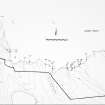
Chapel, Kirk o' Banks or Kirk o' Tang: The outlines on the turf marking the foundations of this chapel are clearly visible close beside the sea to the E of the Burn of Rattar. It appears to have been a chancelled building with long axis E-W, measuring interiorly about 32ft by 12ft and about 36ft by 15ft overall and of undressed dry stone construction. What appears to have been the wall of the chancel occurs at 17ft from the W end.
RCAHMS 1911; R Campbell 1873.
The grass-covered footings of this chapel measure some 5.0m by 12.0m long with an internal division, in which traces of walling can be seen. The surrounding graveyard is enclosed by a D-shaped, grass-covered bank, surviving to a maximum height of 0.5m. The tradition of this site is well known locally.
Revised at 1:2500.
Visited by OS (R B) 23 February 1965.
A small church with chancel, about 49ft by 28ft over spread banks. The walls appear as turf-covered banks 2 to 3ft high with some stone protruding. It forms the NW corner of a small irregular enclosure whose walls appear as low, turf-covered banks 1ft to 1ft 6ins high, from which a few stones protrude.
A D S MacDonald and L R Laing 1969.
This chapel bears a resemblance in plan, dimension, and situation to the Chapel of Noss (HU54SW 9) from which has come an early cross-slab. Its situation in relation to its burial ground suggests that the enclosing wall of the latter is secondary. The fact that a pagan burial (ND27SE 7) took place immediately to the N of the chapel suggests that it may have fallen out of use by the time of that burial, ie. possibly abut 1000, especially as it is likely to have lain within the original burial area of the chapel. No additional information (Batey 1982).
C E Batey 1982; Information from OS.
The rather imprecise remains of the chapel are generally as described and planned by the previous authorities. The original extent of the D-shaped enclosing bank is uncertain as the ground to the N of the chapel has been considerably disturbed by a later track and rig and furrow ploughing, destroying any evidence for the continuation of the enclosure which may have occured on this side. It could not be judged from ground evidence whether this surrounding enclosure post-dates the chapel.
Visited by OS (J B) 5 May 1982.
Project (1980 - 1982)
Field Visit (1982)
This chapel bears a resemblance in plan, dimension, and situation to the Chapel of Noss (HU54SW 9) from which has come an early cross-slab. Its situation in relation to its burial ground suggests that the enclosing wall of the latter is secondary. The fact that a pagan burial (ND27SE 7) took place immediately to the N of the chapel suggests that it may have fallen out of use by the time of that burial, ie. possibly abut 1000, especially as it is likely to have lain within the original burial area of the chapel. No additional information (Batey 1982).
C E Batey 1982; Information from OS.

