
Pricing Change
New pricing for orders of material from this site will come into place shortly. Charges for supply of digital images, digitisation on demand, prints and licensing will be altered.
Fethaland, Isle Of Fethaland


Graffiti (Post Medieval), Steatite Workings (Period Unknown)
Site Name Fethaland, Isle Of Fethaland
Classification Graffiti (Post Medieval), Steatite Workings (Period Unknown)
Canmore ID 884
Site Number HU39SE 5
NGR HU 37800 94482
Datum OSGB36 - NGR
Permalink http://canmore.org.uk/site/884


- Council Shetland Islands
- Parish Northmavine
- Former Region Shetland Islands Area
- Former District Shetland
- Former County Shetland
HU39SE 5 3778 9448.
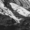
(Area: HU 377 943) The most extensive group of steatite workings on Shetland occurs on a precipitous outcrop close to the sea at Cleber Geos, on the east side of the Isle of Fethaland. Though they cannot be dated, there are plentiful traces of the cutting of urns, bowls and vessels of all sorts.
RCAHMS 1946, visited 1931
Centred at HU 3780 9450, old steatite workings as described.
Visited by OS(RL) 17 May 1969
Field Visit (9 August 1931)
Steatite Workings, Fethaland.
Close to the sea at Cleber Geos, on the E. side of the peninsula known as the Isle of Fethaland, is a precipitous outcrop of steatitic rock, the surface of which bears plentiful traces of the cutting out of urns, bowls, and vessels of all sorts (Figs.550 and 551). This is the most extensive group of steatite workings in Shetland, and was first recorded in 1877 (1) when, however, the significance of the markings on the rock was not understood. The fact that steatite urns were in use as early as the Bronze Age indicates that the practice of making them has had a long history, although the cuttings now visible cannot be dated. It is interesting to note that exactly similar methods of working steatite were employed by the aborigines in many parts of North America. For a full account of the processes, the tools used, and the geographical distribution of the quarries, with illustrations and some references to other literature, see Bulletin 60 of the Bureau of American Ethnology, pt. i, pp. 228-40.
RCAHMS 1946, visited 9 August 1931
(1) PSAS, xii (1876-8), pp. 202-5.
9 August 193I.
Field Visit (30 August 2015)
Found site as described by RCAHMS and OS with extensive workings stretching approximately 30 metres at mid level of cliffs and for 30 metres to the sea edge. Scores of bowl and box shapes have been cut in addition to other odd shapes, tool marks and graffiti. Large debris field runs from the left side toward the sea as well where large accumulations mix with blocks which have fallen away though difficult to discern what is natural erosion. Greatest threats are continued graffiti and erosive forces due largely to land collapse rather than sea action.
Visited by Scotland's Coastal Heritage at Risk (SCHARP) 30 August 2015
Field Visit
Several small outcrops and a sheer vertical mass of steatite form part of the coast edge. The vertical face is marked with both modern graffiti and tool marks which may be of earlier date. Grass-covered heaps of stone debris are strewn towards the base of the cliff and may derive from quarrying. There is little evidence of the 'extensive' workings described by RCAHMS and OS surveyors, and it may be that the area has been damaged by erosion.
Visited by Scotland's Coastal Heritage at Risk (SCHARP)

