
Pitlessie


Barrow (Prehistoric)(Possible), Cropmark(S) (Period Unknown), Henge (Neolithic) - (Bronze Age)(Possible), Rig And Furrow (Medieval) - (Post Medieval)
Site Name Pitlessie
Classification Barrow (Prehistoric)(Possible), Cropmark(S) (Period Unknown), Henge (Neolithic) - (Bronze Age)(Possible), Rig And Furrow (Medieval) - (Post Medieval)
Canmore ID 88369
Site Number NO30NW 138
NGR NO 33813 09557
Datum OSGB36 - NGR
Permalink http://canmore.org.uk/site/88369


- Council Fife
- Parish Cults
- Former Region Fife
- Former District North East Fife
- Former County Fife
NO30NW 138 338130 09557
The possible henge was bisected by a trench along its long axis for the laying of electricity cables in 1998.
Information contained in a letter from M. Ritchie, Historic Scotland, 7 December 1998.
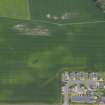
Aerial photography (RCAHMSAP 1993, 1994) has identified a series of cropmarks in the field immediately to the SE of Priestfield Maltings (NO30NW 30). The cropmarks include a possible henge monument at NO 3381 0953. The henge is slightly oval in plan, with a maximum diameter of about 15m, and has one entrance on the NNW side. Also identified 35m to the N are two arcs of ditches with a dark cropmark patch between which may represent a possible barrow with a diameter of about 20m. Various other cropmarks are visible in this field, including a linear cropmark and rig and furrow cultivation.
Information from RCAHMS (KB) 22 January 1999

