
Keiss


Pillbox (20th Century)
Site Name Keiss
Classification Pillbox (20th Century)
Alternative Name(s) Wic 097
Canmore ID 88210
Site Number ND36SE 33
NGR ND 35530 61326
Datum OSGB36 - NGR
Permalink http://canmore.org.uk/site/88210


- Council Highland
- Parish Wick
- Former Region Highland
- Former District Caithness
- Former County Caithness
ND36SE 33 35530 61326
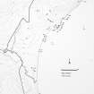
ND 3555 6137 A brick and concrete modern pillbox at the beach head. It is hexagonal and complete, it's sides measuring from 3 to 5m and 1.25 to 2.3m high. The roof is grass-covered.
C E Batey Caithness Coastal Survey 1981.
This possible type 24 pillbox is visible on RAF vertical air photographs (106G/Scot/UK 75, 3003-3004, flown 9 May 1946), just above the high water mark about 400m S of Keiss Castle and about 164m N of Whitegate broch (ND36SE 3).
Information from RCAHMS (DE), October 2004
Project (1980 - 1982)
Field Visit (1981)
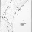
ND 3555 6137 A brick and concrete modern pillbox at the beach head. It is hexagonal and complete, it's sides measuring from 3 to 5m and 1.25 to 2.3m high. The roof is grass-covered.
C E Batey Caithness Coastal Survey 1981.
Note (October 2004)
This possible type 24 pillbox is visible on RAF vertical air photographs (106G/Scot/UK 75, 3003-3004, flown 9 May 1946), just above the high water mark about 400m S of Keiss Castle and about 164m N of Whitegate broch (ND36SE 3).
Information from RCAHMS (DE), October 2004

