
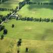
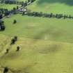
Upsettlington


Plantation Bank (Period Unassigned)(Possible)
Site Name Upsettlington
Classification Plantation Bank (Period Unassigned)(Possible)
Canmore ID 88183
Site Number NT84NE 44
NGR NT 8858 4659
Datum OSGB36 - NGR
Permalink http://canmore.org.uk/site/88183


- Council Scottish Borders, The
- Parish Ladykirk
- Former Region Borders
- Former District Berwickshire
- Former County Berwickshire
NT84NE 44 8858 4659
A circular earthwork of artificial construction, depicted but not noted on the current OS map (OS 1:10000 map, 1980).
Information from Dr G A C Binnie, Ladykirk 4 December 1991.
Visible on OS air photograph (OS 71/050/032).

