
Balta, Geo Of The Brough


Broch (Iron Age)
Site Name Balta, Geo Of The Brough
Classification Broch (Iron Age)
Alternative Name(s) Balta Isle
Canmore ID 88
Site Number HP60NE 2
NGR HP 6600 0895
Datum OSGB36 - NGR
Permalink http://canmore.org.uk/site/88


- Council Shetland Islands
- Parish Unst
- Former Region Shetland Islands Area
- Former District Shetland
- Former County Shetland
HP60NE 2 6600 0895.
(HP 6601 0897) Brough (OE)
OS 6" map, Shetland, 2nd ed. (1900)
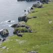
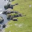
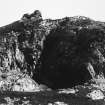
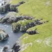
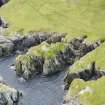
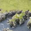
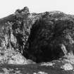
A broch built on a stack, the lower part of which is joined to the mainland. The building covers almost one-third of the whole summit, but the stack has suffered so much from erosion that at one place the outer face of the wall has entirely disappeared, while the wall itself has been reduced to its lower courses. The debris has been used in the construction of a watch-house, now also ruinous, over its west side. Within this superstructure the broch entrance can still be traced. It is 3' wide, and the wall here has been about 14'3" thick. The central court has originally had a diameter of 23'6", but it has subsequently been much reduced in size by the erection of a concentric wall 4' thick against the inner face of the primary wall (?wheel-house).
RCAHMS 1946
The overall diameter of this broch is 15.3m. The wall thickness varies from 4.0m on the seaward side to 4.9m at the entrance. There are footings of a curved wall in the centre of the broch extending from the N. side of the entrance and abutting onto the interior concentric wall noted by RCAHMS, opposite the entrance. There are no piers or other suggestions of a wheelhouse. On the landward side of the broch there is a suggestion of out-buildings, but the remains are very indefinite. Otherwise as described by RCAHMS.
Visited by OS (R L) 30 April 1969.
Publication Account (2002)
HP60 2 BALTA (‘Geo of the Brough’ or ‘Balta Isle Broch’)
HP/660090.
Probable broch on Balta Island, a rock stack off the shore of Unst. The stack has badly eroded, removing part of the outer face of the structure. A watch house, now ruined, has been built from the debris and part of the broch entrance can be seen inside it [2]. This is 3 ft. wide and 14 ft. 3 ins. long, the thickness of the wall. The central court has been 23 ins. 6 ins. across and a secondary wall 4 ft. thick has been built against it. The external diameter was measured at 15.3m in 1969 and the wall from 4.0m thick on the seaward side to 4.9m at the entrance; a curved wall was noted in the middle abutting against the secondary wall [1].
Sources: 1. OS card HP 60 NE 2: 2. RCAHMS 1946, vol. 3, no. 1596, 143 and fig. 600 (pl.).
E W MacKie 2002

