
Auchenskeoch Castle Farm


Farmstead (Period Unassigned)
Site Name Auchenskeoch Castle Farm
Classification Farmstead (Period Unassigned)
Alternative Name(s) Auchenskeock; Caulkerbush Castle Farm; Castle Farm
Canmore ID 87895
Site Number NX95NW 31
NGR NX 91793 58842
Datum OSGB36 - NGR
Permalink http://canmore.org.uk/site/87895


- Council Dumfries And Galloway
- Parish Colvend And Southwick
- Former Region Dumfries And Galloway
- Former District Stewartry
- Former County Kirkcudbrightshire
NX95NW 31.00 91795 58836
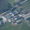
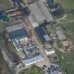
Castle Farm
and remains of Auchenskeock Castle
Castle Farmhouse [NAT]
OS (GIS) MasterMap, July 2009.
NX95NW 31.01 Horse Gin
Location formerly entered as NX 91793 58842.
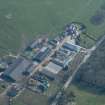
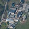
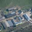
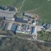
For Auchenskeock or Auchenskeoch Castle (situated within steading area, at NX 91742 58873), see NX95NW 2.
A courtyard farmstead, comprising five roofed buildings, one of which is a horse-engine (NX95NW 31.01) and two unroofed buildings annotated 'Sheds' is depicted on the 1st edition of the OS 6-inch map (Kirkcudbrightshire 1854, sheet 47). Four roofed buildings and one partially roofed building is shown on the OS 1:10000 map (1980).
Information from RCAHMS (AKK) 27 June 2000.
See also: NX95NW 2 Auchenskeock Castle

