
Following the launch of trove.scot in February 2025 we are now planning the retiral of some of our webservices. Canmore will be switched off on 24th June 2025. Information about the closure can be found on the HES website: Retiral of HES web services | Historic Environment Scotland
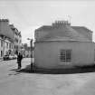
Portpatrick, 35 Main Street, Tollhouse


Toll House (Post Medieval)(Possible)
Site Name Portpatrick, 35 Main Street, Tollhouse
Classification Toll House (Post Medieval)(Possible)
Alternative Name(s) Patrick Street
Canmore ID 87842
Site Number NX05SW 37
NGR NX 00028 54212
Datum OSGB36 - NGR
Permalink http://canmore.org.uk/site/87842

- Council Dumfries And Galloway
- Parish Portpatrick
- Former Region Dumfries And Galloway
- Former District Wigtown
- Former County Wigtownshire
NX05SW 37 00028 54212
(Location cited as NX 000 542). Tollhouse, early 19th century. A single-storey rubble building with a rounded end.
J R Hume 1976.

