
Crieff To Dalnacardoch Military Road


Military Road (18th Century)
Site Name Crieff To Dalnacardoch Military Road
Classification Military Road (18th Century)
Alternative Name(s) Glen Cochill
Canmore ID 87602
Site Number NN94SW 30
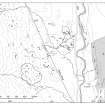
NGR NN 9053 4100
NGR Description NN 9098 4000 to NN 9000 4212
Datum OSGB36 - NGR
Permalink http://canmore.org.uk/site/87602


- Council Perth And Kinross
- Parish Little Dunkeld
- Former Region Tayside
- Former District Perth And Kinross
- Former County Perthshire
NN94SW 30.00 9099 4000 to 9000 4212 MR 3
General Wade's Military Road
OS 1:10000 map (1991)
NN94SW 30.01 NN 9081 4047 Glen Cochill Bridge.
NN94SW 30.02 NN 9022 4166 Grouse Butts Culvert.
The military road heads NNW on a track through Glen Cochill, which becomes fairly marshy in parts.
J B Salmond 1938.
NN 9099 4000 - 9082 4045 slight heather-covered hollow c.4m wide
NN 9082 4045 - 9044 4148 slight heather-covered hollow-way with upcast bank on either side, 3.5m wide.
NN 9044 4148 - 9000 4212 modern estate road overlies military road.
NN 9022 4166 modern culvert (NN94SW 30.02).
Visited by OS (WJD) November 1970.
The track through Glen Cochill tends to be rather wet. The bridge (NN94SW 30.01) at NN 908 405 seems to be old enougb on the underside to provide interest.
W Taylor 1976.
There is a discrepancy between the observation of Taylor (1976) and the recording of the OS (1970) in that Taylor mentions a bridge (NN94SW 30.01) at NN 908 405, whereas this does not appear in the OS record.
Information from RCAHMS (MW) 28 September 1999.

