
Whitrope Tunnel


Railway Tunnel (19th Century), Spoil Heap(S) (19th Century)
Site Name Whitrope Tunnel
Classification Railway Tunnel (19th Century), Spoil Heap(S) (19th Century)
Alternative Name(s) The Waverley Line; Sandy Edge; The Border Union Railway
Canmore ID 86458
Site Number NT50SW 11.01
NGR NT 52451 01183
NGR Description NT 52664 00673 to NT 52230 01702
Datum OSGB36 - NGR
Permalink http://canmore.org.uk/site/86458


- Council Scottish Borders, The
- Parish Castleton
- Former Region Borders
- Former District Roxburgh
- Former County Roxburghshire
NT50SW 11.01 52664 00673 to 52230 01702
Whitrope Tunnel [NAT]
OS 1:10,000 map, 1985.
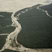
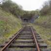
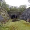
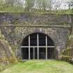
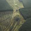
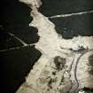
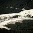
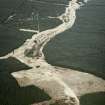
This tunnel formerly carried the Edinburgh-Carlisle major line of the North British Rly (the 'Waverley Route') beneath Sandy Edge. The summit of the line is adjacent to the S entrance to the tunnel.
The tunnel crosses the boundary between the parishes of Cavers (to the N) and Castleton (to the S).
Information from RCAHMS (RJCM), 7 February 2006.
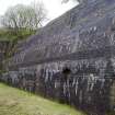
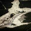
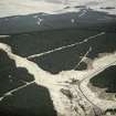
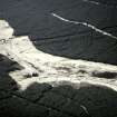
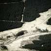
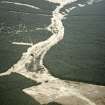
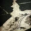
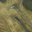
Whitrope tunnel is situated under Sandy Edge. The tunnel is about 1104m long, the N portal in stone is entered through a stone lined cutting (Cavers ph) and the S portal is of random rubble with a stone arch (Castleton ph), the entrance is through a cutting, revetted by steep stone retaining walls. Surface and burn water was drained through drains into a pipe under the trackbed.
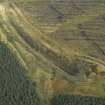
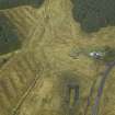
Five spoil heaps from the excavations survive on the surface, at NT 52604 00770, NT 52537 00948, NT 52437 01170, c. NT 5225 0162 and c.NT 5232 0147.
The tunnel is now closed to the public due to the dangerous condition of the S end.
Visited by RCAHMS (DE, AL), 19 May 2010
Publication Account (2007)
One of the longest railway tunnels in Scotland at 1208 yards, containing the summit of the former Waverley
Route 1006 ft above sea level near its south end with an approach gradient from the north of 1 in 96. It is located in desolate country three miles south of Shankend Viaduct and accommodated a double track. On 2 July 1862, the day after the line was opened, ‘passengers looked out on a snow covered landscape dotted with the rusting abandoned equipment’, which was auctioned from 5– 7 January 1863. Special trains stopped at the south end of the tunnel and at Shankend viaduct for the sales which took place as soon as the trains arrived.
The contract for the tunnel at this remote location under difficult ground and weather conditions was overspent. The tunnel, excavated through old red sandstone conglomerate resting on clay slate, stratified sandstone and beds of shale interspersed with thin bands of limestone and sandstone, required partial lining with brick and stone. The appalling wetness of the site, which turned the ground into slurry, caused the contractor many problems. Measurements taken at three shafts in the tunnel workings showed that 425 gallons of water per minute were cascading into the tunnel. A force of 230 men, working at ten faces, cut through the rotten strata. Keeping them relatively dry and getting enough air to them were major problems for Ritson and 2 ft square air boxes were installed worked by fans attached to pumping engines. These had to be steam operated as the horse gins had insufficient capacity. The engineer was John F. Tone and the contractor,
William Ritson. The line closed in 1969 and is now owned by the Forestry Commission. The Waverley Route Heritage Association, formed in 2001, is taking an active interest in reopening the tunnel, now made more difficult by recent roof falls.
R Paxton and J Shipway 2007
Reproduced from 'Civil Engineering heritage: Scotland - Lowlands and Borders' with kind permission from Thomas Telford Publishers.

