|
Manuscripts |
MS 595/11 |
|
Coastal erosion and archaeological monuments in the southern isles, Outer Hebrides: survey report 1994: north Vatersay and southern Mingulay |
1994 |
Item Level |
|
 |
On-line Digital Images |
DP 109550 |
RCAHMS Aerial Photography Digital |
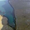
Oblique aerial view of the remains of a fish trap, head dyke, lazy beds and field boundaries at Cornaig Bay, Vatersay, taken from the WNW. |
14/11/2011 |
Item Level |
|
 |
On-line Digital Images |
DP 109554 |
RCAHMS Aerial Photography Digital |
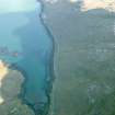
Oblique aerial view of the remains of a fish trap, head dyke, lazy beds and field boundaries at Cornaig Bay, Vatersay, taken from the NE. |
14/11/2011 |
Item Level |
|
 |
On-line Digital Images |
DP 110552 |
RCAHMS Aerial Photography Digital |
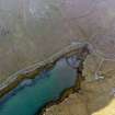
Oblique aerial view of the remains of a fish trap, head dyke, lazy beds and field boundaries at Cornaig Bay, Vatersay, taken from the WNW. |
14/11/2011 |
Item Level |
|
 |
On-line Digital Images |
DP 110588 |
RCAHMS Aerial Photography Digital |
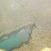
Oblique aerial view of the remains of a fish trap, head dyke, lazy beds and field boundaries at Cornaig Bay, Vatersay, taken from the NE. |
14/11/2011 |
Item Level |
|
|
Manuscripts |
MS 968/14 |
Historic Scotland Archive Project |
Barra and Vatersay
Coastal Assessment Survey report. 2 volumes. |
10/1998 |
Batch Level |
|


