
Roy Geo


Croft (Period Unassigned)
Site Name Roy Geo
Classification Croft (Period Unassigned)
Alternative Name(s) Lat 231
Canmore ID 8592
Site Number ND23NE 24
NGR ND 2753 3569
Datum OSGB36 - NGR
Permalink http://canmore.org.uk/site/8592


- Council Highland
- Parish Latheron
- Former Region Highland
- Former District Caithness
- Former County Caithness
ND23NE 24 2753 3569.
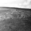
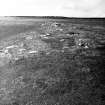
A ruinous, grass covered, post-medieval structure, measuring 21.5m E-W by 5m with a wall 1m thick; and comprising one room with two sub-divisions. There are possible entrances in the SW and SE walls and a rubble platform at the SW corner.
C E Batey 1982.
Project (1980 - 1982)
Field Visit (1982)
A ruinous, grass covered, post-medieval structure, measuring 21.5m E-W by 5m with a wall 1m thick; and comprising one room with two sub-divisions. There are possible entrances in the SW and SE walls and a rubble platform at the SW corner.
C E Batey 1982.

