
Pricing Change
New pricing for orders of material from this site will come into place shortly. Charges for supply of digital images, digitisation on demand, prints and licensing will be altered.
Battledykes


Enclosure (Period Unknown), Pit(S) (Period Unknown), Pit Alignment (Early Prehistoric), Plantation Bank (Period Unknown), Rig And Furrow (Medieval) - (Post Medieval)
Site Name Battledykes
Classification Enclosure (Period Unknown), Pit(S) (Period Unknown), Pit Alignment (Early Prehistoric), Plantation Bank (Period Unknown), Rig And Furrow (Medieval) - (Post Medieval)
Canmore ID 85855
Site Number NO45NE 58
NGR NO 4620 5520
NGR Description Centred on NO 4620 5520
Datum OSGB36 - NGR
Permalink http://canmore.org.uk/site/85855


- Council Angus
- Parish Oathlaw
- Former Region Tayside
- Former District Angus
- Former County Angus
NO45NE 58 4620 5520
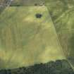
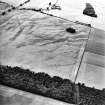
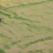
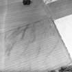
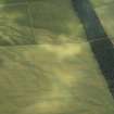
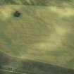
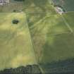
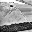
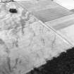
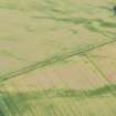
Cropmarks on aerial photographs (RCAHMSAP 1992) have revealed an irregular line of pits running from approximately NO 462 551 to 462 552, south of the Roman Temporary Camp (NO45NE 12). The pits lead up to a semi-circular enclosure which has a very narrow ditch. This enclosure appears as a plantation bank on the 1st ed. OS (Forfarshire sheet XXXII pub. 1865) and the plantation is still visible on CUCAP aerial photographs taken in 1947 (U 84-86). A similar plantation exists at NO 4602 5510 covering a cairn (NO45NE 15).
RCAHMSAP (RHM) 7 September 1995.

