
Burnswark Hill


Scooped Settlement (Iron Age)
Site Name Burnswark Hill
Classification Scooped Settlement (Iron Age)
Alternative Name(s) Burnswark, South Settlement
Canmore ID 85701
Site Number NY17NE 2.12
NGR NY 18773 78479
Datum OSGB36 - NGR
Permalink http://canmore.org.uk/site/85701


- Council Dumfries And Galloway
- Parish Hoddom
- Former Region Dumfries And Galloway
- Former District Annandale And Eskdale
- Former County Dumfries-shire
Field Visit (14 April 1994)
NY 1877 7848 NY17NE 2.12
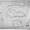
This scooped settlement overlies the SW perimeter of the Roman temporary camp on the SE flank of Burnswark Hill (NY17NE 2.04). It is situated immediately to the SE of the SW entrance of the camp and its bank has clearly been built across the Roman rampart on the SW. Roughly oval on plan, the settlement measures about 22.5m from N to S by 16.5m transversely within a bank which is up to 5.5m thick and 1m high externally, where it is best preserved on the SW. The entrance, on the SE, has been mutilated by cultivation, and the interior has been scooped into the natural slope to a depth of up to 1m. The only feature visible within the interior is a low platform occupying the NE quadrant.
Visited by RCAHMS (JRS), 14 April 1994.
Burnswark, South. Listed as settlement.
RCAHMS 1997.
Measured Survey (16 March 1994)
RCAHMS surveyed the scooped settlement at Burnswark Hill on 16 March 1994 with plane-table and self-reducing alidade at a scale of 1:500. The plan was redrawn in ink and published at a scale of 1:1000 (RCAHMS 1997, Fig. 198).

