
Burg, Mull


Township (Period Unassigned)
Site Name Burg, Mull
Classification Township (Period Unassigned)
Canmore ID 85150
Site Number NM42NW 7
NGR NM 425 265
NGR Description Centred NM 425 265
Datum OSGB36 - NGR
Permalink http://canmore.org.uk/site/85150

- Council Argyll And Bute
- Parish Kilfinichen And Kilvickeon
- Former Region Strathclyde
- Former District Argyll And Bute
- Former County Argyll
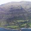
NM42NW 7 centred on 425 265
Burgh. An old habitation comprising a few crofts.
Name Book, Argyll 1878
A depopulated settlement consisting of about seventeen roofless buildings and other enclosures.
Visited by OS (DWR) 24 May 1972
A township comprising nineteen unroofed buildings, four roofed buildings, six enclosures and a sheepfold is depicted on the 1st edition of the OS 6-inch map (Argyllshire, Island of Mull 1882, sheet cvi). Four unroofed, four roofed buildings, two enclosures, a sheep wash and some sheep pens are shown on the current edition of the OS 1:10000 map (1976).
Information from RCAHMS (SAH) 30 July 1998

