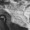
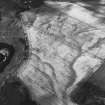
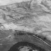
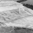
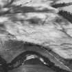
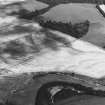
Accessibility

Font Size

100% 150% 200%

Background Colour

Default Contrast
Close Reset

Pricing Change

New pricing for orders of material from this site will come into place shortly. Charges for supply of digital images, digitisation on demand, prints and licensing will be altered. 


Forteviot

Pit Alignment (Prehistoric)

Site Name Forteviot

Classification Pit Alignment (Prehistoric)

Canmore ID 84897

Site Number NO01NE 83

NGR NO 05525 17143

Datum OSGB36 - NGR

Permalink http://canmore.org.uk/site/84897

Ordnance Survey licence number AC0000807262. All rights reserved.
Canmore Disclaimer. © Bluesky International Limited 2025. Public Sector Viewing Terms

Toggle Aerial | View on large map

Digital Images

Administrative Areas

  • Council Perth And Kinross
  • Parish Forteviot
  • Former Region Tayside
  • Former District Perth And Kinross
  • Former County Perthshire

Archaeology Notes

NO01NE 83 NO 05525 17143

References

MyCanmore Image Contributions


Contribute an Image

MyCanmore Text Contributions