
Following the launch of trove.scot in February 2025 we are now planning the retiral of some of our webservices. Canmore will be switched off on 24th June 2025. Information about the closure can be found on the HES website: Retiral of HES web services | Historic Environment Scotland
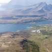
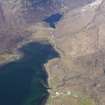
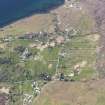
Skye, Torrin


Field System (Period Unassigned), School (Period Unassigned), Township (Period Unassigned)
Site Name Skye, Torrin
Classification Field System (Period Unassigned), School (Period Unassigned), Township (Period Unassigned)
Alternative Name(s) Torran
Canmore ID 84390
Site Number NG52SE 87
NGR NG 579 206
NGR Description centred on NG 579 206
Datum OSGB36 - NGR
Permalink http://canmore.org.uk/site/84390


- Council Highland
- Parish Strath
- Former Region Highland
- Former District Skye And Lochalsh
- Former County Inverness-shire
NG52SE 87 centred on 579 206
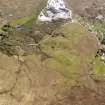
NG 5743 2100: To the S side of the Allt Slapin at 15m OD is a ruinous croft house. The ruins consist of a two compartment house with square internal and external corners which measure 16m x 5.5m over walls 0.8m wide. A door opening 1.0m wide lies in the NE wall of each compartment.
Visited 1991.
NMRS MS/530
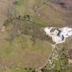
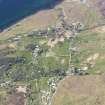
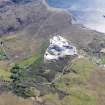
A crofting township comprising sixty-four roofed buildings, one of which is annotated as a school, two partially roofed buildings and eight unroofed buildings is depicted on the 1st edition of the OS 6-inch map (Inverness-shire, Isle of Skye 1881, sheet xlvi). Also shown is a field-system (NG585 207).
Fifty-three roofed, one partially roofed and twenty-two unroofed buildings and the field-system are shown on the current edition of the OS 1:10560 map (1968).
Information from RCAHMS (SAH) 4 December 1996

