
Forth Defences, Outer, Inchkeith, "i", Later "m" Group, 6-inch Gun Emplacements


Coastal Battery (19th Century) - (20th Century), Coastal Battery (Second World War), Coastal Battery (First World War)
Site Name Forth Defences, Outer, Inchkeith, "i", Later "m" Group, 6-inch Gun Emplacements
Classification Coastal Battery (19th Century) - (20th Century), Coastal Battery (Second World War), Coastal Battery (First World War)
Alternative Name(s) Fort No.2, North Gun No. 1
Canmore ID 84261
Site Number NT28SE 5.02
NGR NT 29241 83120
Datum OSGB36 - NGR
Permalink http://canmore.org.uk/site/84261


- Council Fife
- Parish Kinghorn
- Former Region Fife
- Former District Kirkcaldy
- Former County Fife
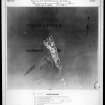
The northernmost battery was built on the site of the Victorian North Battery No. 2. In 1879 a single 10-inch Rifled Muzzle Loader had been emplaced here. According to the Fort Record Book, the gun was replaced in 1891 by a 6-inch BL gun, the 10-inch gun being sent to Kinghorn. [The National Archives WO192/251]. The battery was rebuilt to take two 6-inch guns, which were in place by September 1904 (at which time the battery was known as "I" Group). A drawing on War Office file WO 78/5180, unfortunately undated, shows plans and cross-sections of the battery, apparently very much as built.
The battery was, confusingly, first called "I" Group, but became "M" Group at some time after 1904.
The battery was struck off the approved armament of the island in 1906 and the two guns were replaced in 1907 by different 6-inch guns for practice use; these guns were themselves removed in November 1909, when the School of Gunnery was moved from Leith to Broughty Castle. [The National Archives WO 192/251].
The battery was brought back into use in June 1915 using two guns brought from batteries in England and mounted in the existing emplacements. One of the guns, M1, was dismounted almost immediately and moved to emplacement 2 in battery Group “H” (confusingly, later re-named Group “L”) on the island, during September 1915. The battery is recorded as mounting a single 6-inch gun in the definitive summary of the Forth defences dated October 1916. [WO 78/5179].
By the time of the Second World War the single gun is labelled “North Gun No. 1”.
Information from HS/RCAHMS World War One Audit Project (GJB) 30 October 2013.
NT28SE 5.02 29241 83120
For Victorian period gun battery remains see also NT28SE 1.02
The North Battery housed 2x 6-inch Mk VII/II guns which were installed in September 1904.
J Guy 1994; NMRS MS 810/3; PRO WO/192/251.
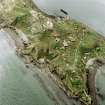
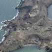
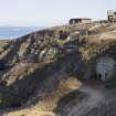
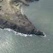
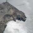
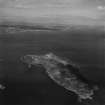
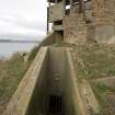
This battery is situated 98m S of the fog horn located on the extreme northern tip of the Island (NT28SE 13). The battery Observation Post (BOP) is another 21m to the S. The BOP is built above the remains of the Victorian Fort No.2 (NT28SE 1.02) and the below ground magazines and accommodation rooms have been utilised in the operation of the later 20th cenutry battery.
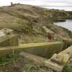
The single circular concrete emplacement with the brick and concrete canopy supported by steel beams and stanchions is of later date. To the rear of the emplacement are several ready use ammunition lockers and the entrance to a tunnel/corridor leading to the 19th century magazines. The traces of at least one painted wall sign was noted and like the larger gun emplacements to the S, two metal rings are built into the wall of the gun pit to allow the servicing and replacement of gun barrels and breeches to take place.
The battery Observation Post stands to two storeys high is constructed of brick and concrete. The tower has the appearance of two phases with a main observation platorm facing NE to cover the N channel, but an additional upper storey with bi-driectional viewing. Entrances to the underground areas (NT28SE 1.02) can be found to the S and W.
Annotated as 'M group' on the WO plan of the Island (copy in RCAHMS as MS 879/83).
Visited by RCAHMS (DE, AL, JM), 25 February, 4 and 5th March 2009
Project (March 2013 - September 2013)
A project to characterise the quantity and quality of the Scottish resource of known surviving remains of the First World War. Carried out in partnership between Historic Scotland and RCAHMS.

