
Donibristle Airfield


Military Airfield (First World War), Military Airfield (20th Century), Military Airfield (Second World War)
Site Name Donibristle Airfield
Classification Military Airfield (First World War), Military Airfield (20th Century), Military Airfield (Second World War)
Alternative Name(s) Hms Merlin; Dalgety Bay
Canmore ID 84226
Site Number NT18SE 30
NGR NT 1600 8400
NGR Description Centred NT 1600 8400
Datum OSGB36 - NGR
Permalink http://canmore.org.uk/site/84226


- Council Fife
- Parish Dalgety
- Former Region Fife
- Former District Dunfermline
- Former County Fife
Donibristle aerodrome was developed from September 1917 to cater for the expansion of naval flying in southern Scotland. It lay close to the naval base at Rosyth, on an emergency landing ground previously established by No. 77 Home Defence Squadron (although it was never used by the squadron). The station was designed to maintain the aeroplanes of the fleet – both land-planes and seaplanes – a growing commitment after it was decided to equip all light and battle cruisers with onboard aircraft. The base was to be the principal repair depot for fleet aircraft, the store for reserve aircraft and a landing ground for aeroplanes coming in from their ships.
At the time of the 1918 RAF survey of aerodromes, the main station covered an area of 53 hectares (measuring 1005m by 550m), with its technical buildings in its north-west corner and the accommodation area in the north-east. The technical area included four aeroplane sheds measuring 61m by 30m and an erecting shed and a stores shed of the same size; there was a further, smaller, stores shed, as well as a range of workshops and ammunition stores. The establishment of the aerodrome had not been finalised at the time of the 1918 survey, but extensive accommodation for men and women was under construction.
The main site was linked to the shore by a railway line 2.6km long, connected at its NE end to the main railway line that ran along the northern boundary of the aerodrome. The route of the line was mapped on the 1926-7 edition of the OS 25-inch map of the area. At its SW end the railway ran out onto a pier for the seaplanes, which survives. The railway was used to transport seaplanes up to the main part of the aerodrome. There were two store sheds and a bomb store near the pier.
Donibristle was one of only two Scottish aerodromes that continued in active military use after the First World War and then through the Second World War. Since its closure in 1959 most of the main part of the aerodrome has been occupied by Donibristle Industrial Estate, but about 16 buildings of the First World War accommodation complex survive as commercial premises at the south-east corner of the estate. Second World War buildings also survive.
Information from HS/RCAHMS World War One Audit Project (GJB) 31 May 2013
NT18SE 18.00 centred 1600 8400
NT18SE 30.01 NT 1640 8443 Pillbox
NT18SE 30.02 NT 1575 8434 Air Raid Shelter
NT18SE 30.03 NT 1617 8427 Building
NT18SE 30.04 NT 1754 8431 Radio Beacon
NT18SE 30.05 NT 16343 84372 Huts
Opened in 1917 as a landing ground, and handed over to the RNAS in August of that year it was reduced to Care and Maintainance in 1921, re-opening in 1925 as a shore base for disembarked naval aircraft.
After closure in the 1950s the site has been built on by an industrial and housing estates. No hangars survive, but some barrack blocks are still in use as offices, and some stretches of runway survive with the dotted white centre line markings. In the former red-brick officers mess is a fine coloured dado cartoon mural, depicting aircrew and officers as egyptians undertaking airfield and administative tasks.
D J Smith 1983; RCAHMS 1999
Archaeological Evaluation (11 December 2013 - 12 December 2013)
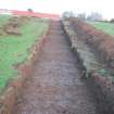
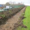
AOC Archaeology Group was commissioned by their client Springfield Properties PLC to undertake an archaeological evaluation on a proposed development of a brownfield site set within the grounds of the former Donibristle Airfield, Dalgety Bay, Fife (NGR: NT 1610 8427). Works consisted of an archaeological evaluation of eight trenches totalling 505 linear metres. The evaluation revealed no significant archaeological remains. It was apparent that the area available for archaeological evaluation had been heavily truncated by recent landscaping.
Information from Rob Engl (AOC), 18 December 2013
OASIS ID aocarcha1-167104
Project (March 2013 - September 2013)
A project to characterise the quantity and quality of the Scottish resource of known surviving remains of the First World War. Carried out in partnership between Historic Scotland and RCAHMS.

