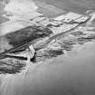
 |
On-line Digital Images |
SC 1004831 |
RCAHMS Aerial Photography |
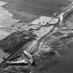
Oblique aerial view of the farmsteading, harbour and the remains of the windmill, cottage and broch taken from the E |
13/3/2002 |
Item Level |
|
 |
On-line Digital Images |
SC 1675251 |
RCAHMS Aerial Photography |
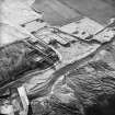
Oblique aerial view of the farmsteading, harbour and the remains of the windmill, cottage and broch taken from the ENE |
13/3/2002 |
Item Level |
|
 |
On-line Digital Images |
SC 1675254 |
RCAHMS Aerial Photography |
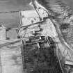
Oblique aerial view of the farmsteading and the remains of the windmill, cottages and broch, taken from the SE |
13/3/2002 |
Item Level |
|
 |
On-line Digital Images |
SC 1675256 |
RCAHMS Aerial Photography |
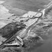
Oblique aerial view of the farmsteading, harbour and the remains of the windmill, cottage and broch taken from the E |
13/3/2002 |
Item Level |
|
 |
On-line Digital Images |
SC 1675257 |
RCAHMS Aerial Photography |
Oblique aerial view of the farmsteading, harbour and the remains of the windmill, cottage and broch taken from the E |
13/3/2002 |
Item Level |
|
 |
On-line Digital Images |
SC 2353053 |
Records of the Ordnance Survey, Southampton, Hampshire, England |
Castlehill, ND16NE 11, Ordnance Survey index card, page number 1, Recto |
c. 1958 |
Item Level |
|
 |
On-line Digital Images |
SC 2353054 |
Records of the Ordnance Survey, Southampton, Hampshire, England |
Castlehill, ND16NE 11, Ordnance Survey index card, page number 2, Verso |
c. 1958 |
Item Level |
|
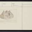 |
On-line Digital Images |
SC 2353055 |
Records of the Ordnance Survey, Southampton, Hampshire, England |
Castlehill, ND16NE 11, Ordnance Survey index card, Recto |
c. 1958 |
Item Level |
|


