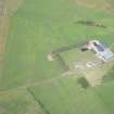
|
Photographs and Off-line Digital Images |
C 55314 |
RCAHMS Aerial Photography |
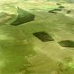
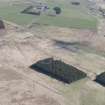
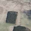
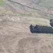
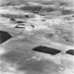
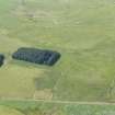
Pennymuir, oblique aerial view, taken from the WSW, centred Roman Temporary Camps, a linear earthwork and an area of rig. The course of 'Dere Street' is shown in the centre of the photograph. |
30/8/1995 |
Item Level |
|
|
Photographs and Off-line Digital Images |
C 55315 |
RCAHMS Aerial Photography |
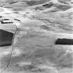
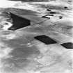
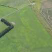
Pennymuir, oblique aerial view, taken from the SW, centred on Roman Temporary Camps, a linear earthwork and an area of rig. The course of 'Dere Street' is shown in the centre of the photograph. |
30/8/1995 |
Item Level |
|
|
Photographs and Off-line Digital Images |
C 55316 |
RCAHMS Aerial Photography |
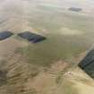
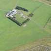
Pennymuir, oblique aerial view, taken from the SW, centred on Roman Temporary Camps and a linear earthwork. The course of 'Dere Street' is visible in the centre of the photograph. |
30/8/1995 |
Item Level |
|
|
Photographs and Off-line Digital Images |
C 55318 |
RCAHMS Aerial Photography |
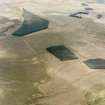
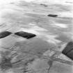
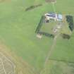
Pennymuir, oblique aerial view, taken from the NE, centred on Roman Temporary Camps, a linear earthwork and an area of rig. The course of 'Dere Street' is visible in the bottom half of the photograph. |
30/8/1995 |
Item Level |
|
|
Photographs and Off-line Digital Images |
C 53935 CN |
RCAHMS Aerial Photography |
Pennymuir, oblique aerial view, taken from the SW, centred on Roman Temporary Camps, a linear earthwork and an area of rig. The course of 'Dere Street' is visible in the top right half of the photograph. |
30/8/1995 |
Item Level |
|
|
Photographs and Off-line Digital Images |
C 53938 CN |
RCAHMS Aerial Photography |
Pennymuir, oblique aerial view, taken from the NE, centred on Roman Temporary Camps, a linear earthwork and an area of rig. The course of 'Dere Street' is visible in the bottom half of the photograph. |
30/8/1995 |
Item Level |
|
 |
On-line Digital Images |
SC 972490 |
RCAHMS Aerial Photography |
Pennymuir, oblique aerial view, taken from the SW, centred on Roman Temporary Camps, a linear earthwork and an area of rig. The course of 'Dere Street' is visible in the top right half of the photograph. |
30/8/1995 |
Item Level |
|
 |
On-line Digital Images |
SC 1164110 |
RCAHMS Aerial Photography |
Pennymuir, oblique aerial view, taken from the NE, centred on Roman Temporary Camps, a linear earthwork and an area of rig. The course of 'Dere Street' is visible in the bottom half of the photograph. |
30/8/1995 |
Item Level |
|
 |
On-line Digital Images |
DP 156906 |
RCAHMS Aerial Photography Digital |
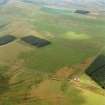
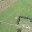
Oblique aerial view of Pennymuir, looking NE. |
30/4/2013 |
Item Level |
|
 |
On-line Digital Images |
DP 156907 |
RCAHMS Aerial Photography Digital |
Oblique aerial view of Pennymuir, looking NNW. |
30/4/2013 |
Item Level |
|
 |
On-line Digital Images |
DP 156913 |
RCAHMS Aerial Photography Digital |
Oblique aerial view of Pennymuir, looking E. |
30/4/2013 |
Item Level |
|
 |
On-line Digital Images |
SC 1749073 |
RCAHMS Aerial Photography |
Pennymuir, oblique aerial view, taken from the SW, centred on Roman Temporary Camps, a linear earthwork and an area of rig. The course of 'Dere Street' is visible in the top right half of the photograph. |
30/8/1995 |
Item Level |
|
 |
On-line Digital Images |
SC 1749076 |
RCAHMS Aerial Photography |
Pennymuir, oblique aerial view, taken from the NE, centred on Roman Temporary Camps, a linear earthwork and an area of rig. The course of 'Dere Street' is visible in the bottom half of the photograph. |
30/8/1995 |
Item Level |
|
 |
On-line Digital Images |
SC 1749083 |
RCAHMS Aerial Photography |
Pennymuir, oblique aerial view, taken from the WSW, centred Roman Temporary Camps, a linear earthwork and an area of rig. The course of 'Dere Street' is shown in the centre of the photograph. |
30/8/1995 |
Item Level |
|
 |
On-line Digital Images |
SC 1749084 |
RCAHMS Aerial Photography |
Pennymuir, oblique aerial view, taken from the SW, centred on Roman Temporary Camps, a linear earthwork and an area of rig. The course of 'Dere Street' is shown in the centre of the photograph. |
30/8/1995 |
Item Level |
|
 |
On-line Digital Images |
SC 1749085 |
RCAHMS Aerial Photography |
Pennymuir, oblique aerial view, taken from the SW, centred on Roman Temporary Camps and a linear earthwork. The course of 'Dere Street' is visible in the centre of the photograph. |
30/8/1995 |
Item Level |
|
 |
On-line Digital Images |
SC 1749087 |
RCAHMS Aerial Photography |
Pennymuir, oblique aerial view, taken from the NE, centred on Roman Temporary Camps, a linear earthwork and an area of rig. The course of 'Dere Street' is visible in the bottom half of the photograph. |
30/8/1995 |
Item Level |
|
 |
On-line Digital Images |
DP 282178 |
Historic Environment Scotland |
Oblique aerial view. |
9/8/2018 |
Item Level |
|
 |
On-line Digital Images |
DP 282179 |
Historic Environment Scotland |
Oblique aerial view. |
9/8/2018 |
Item Level |
|
 |
On-line Digital Images |
DP 282180 |
Historic Environment Scotland |
Oblique aerial view. |
9/8/2018 |
Item Level |
|
 |
On-line Digital Images |
DP 282181 |
Historic Environment Scotland |
Oblique aerial view. |
9/8/2018 |
Item Level |
|
 |
On-line Digital Images |
DP 282182 |
Historic Environment Scotland |
Oblique aerial view. |
9/8/2018 |
Item Level |
|
 |
On-line Digital Images |
DP 282183 |
Historic Environment Scotland |
Oblique aerial view. |
9/8/2018 |
Item Level |
|
|
Digital Files (Non-image) |
TM 000541 |
Records of the Royal Commission on the Ancient and Historical Monuments of Scotland (RCAHMS), Edinbu |
Zip file containing all survey linework data recorded during the RCAHMS Afforestable Land Survey of Kale Water 1999 |
1999 |
Item Level |
|


