
Following the launch of trove.scot in February 2025 we are now planning the retiral of some of our webservices. Canmore will be switched off on 24th June 2025. Information about the closure can be found on the HES website: Retiral of HES web services | Historic Environment Scotland
Castle Fraser, Obelisk


Commemorative Monument (Period Unassigned)
Site Name Castle Fraser, Obelisk
Classification Commemorative Monument (Period Unassigned)
Alternative Name(s) Castle Fraser Estate; Castle Fraser Policies; Courtcairn Farm
Canmore ID 83647
Site Number NJ71SW 6.13
NGR NJ 71749 11862
Datum OSGB36 - NGR
Permalink http://canmore.org.uk/site/83647

- Council Aberdeenshire
- Parish Cluny
- Former Region Grampian
- Former District Gordon
- Former County Aberdeenshire
NJ71SW 6.13 71749 11862
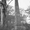
This monument is situated in a shelter-belt 530m W of Courtcairn farmsteading (NJ71SW 29). Constructed of dressed granite blocks, it comprises an obelisk set into a base 1.18m square and 0.96m in height. The obelisk is 0.96m square in section and tapers to a ball finial some 7m above the ground.
Visited by RCAHMS (JRS, IF), 18 September 1996.

