
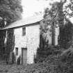
Knocknalling Stables


Stable(S) (Period Unassigned)
Site Name Knocknalling Stables
Classification Stable(S) (Period Unassigned)
Canmore ID 83522
Site Number NX58SE 34.02
NGR NX 59700 84845
Datum OSGB36 - NGR
Permalink http://canmore.org.uk/site/83522


- Council Dumfries And Galloway
- Parish Kells
- Former Region Dumfries And Galloway
- Former District Stewartry
- Former County Kirkcudbrightshire
NX58SE 34.02 59700 84845.
NX58SE 34.02 59700 84845
NX58SE 34.00 59702 84823
NX58SE 34.01 59645 84846 Barn

