
St Magnus Hospital And Chapel, Spittal


Burial Ground (Medieval), Chapel (Medieval), Hospital (Medieval)
Site Name St Magnus Hospital And Chapel, Spittal
Classification Burial Ground (Medieval), Chapel (Medieval), Hospital (Medieval)
Canmore ID 8329
Site Number ND15SE 1
NGR ND 1588 5487
NGR Description ND 1587 5488 and ND 1587 5486
Datum OSGB36 - NGR
Permalink http://canmore.org.uk/site/8329


- Council Highland
- Parish Halkirk
- Former Region Highland
- Former District Caithness
- Former County Caithness
ND15SE 1 1588 5487 and 1587 5486
(ND 1587 5486) Site of St Magnus's Hospital (NR)
(ND 1587 5488) St Magnus's Chapel (NR) (In Ruins)
OS 6" map, Caithness, 2nd ed., (1907)
Little is known of the hospital of St Magnus beyond that it was mentioned in 1476 and was still in existence in 1633. The dedication is to the Norse St Magnus, who was executed in 1116.
The chapel of the hospital was also the church of Spittal parish, which was combined with Halkirk and Skinnet parishes in the 16th century.
The site of the S wall of the hospital was pointed out to the OS surveyor in 1872, by which time it had been demolished for many years. It had been 102ft long.
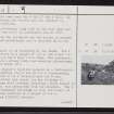
By 1910 the chapel was in ruinous condition. The E gable stood 12ft high, with the side walls averaging 6 to 8ft. It measured about 65 by 19ft within walls 3ft 4ins thick.
The entrance has been near the W end of the S wall. No decorative features are visible and the interior is overgrown with nettles.
The adjoining graveyard, long used by the Clan Gunn and now neglected, was still in occasional use in 1872.
The area of both the graveyard and the church is covered with uninscribed gravestones and is enclosed by an old sunken wall.
Name Book 1872; RCAHMS 1911; RCAHMS 1946; D E Easson 1957; H Scott et al 1915-61
St Magnus's Chapel is as described by the RCAHMS (1911). The N and S walls survive to a height of 1.5m, the E wall to gable height, and the W wall 1.0m high. The graveyard, contained within a grassy bank, has numerous gravestones, the most recent dated 1911.
The site of St Magnus's Hospital appears as a rectangular sunken area measuring 30.5m E-W by 6.0m transversely, with what appears to be a division near its W end. Between the hospital and chapel lie the footings of several buildings with internal divisions, which appear to be contemporary, and associated with the hospital. The S wall of these secondary buildings is also the N wall of the hospital, and survives to a height of 0.4m.
Visited by OS (R B) 12 November 1965
(ND 1588 5487) St Magnus's Hospital & Chapel (NR) (remains of) (NAT)
OS 1:10,000 map, (1976)
St Magnus's Chapel, within a disused graveyard, is as described by the previous authorities. The hospital appears to have been incorrectly located to the 'sunken rectangular area' by the previous OS field surveyor this area, open at the W end, is somewhat damp, and may be the result of later disturbance. The stretch of walling, 6.0m long, exposed along the N side of the sunken area is not the N wall of the hospital as stated, but part of the S wall of a range of buildings, presumably the hospital, which occurs between the sunken area and the chapel, and which is reduced to amorphous, turf-covered footings.
Revised at 1:2500.
Visited by OS (N K B), 17 March 1982.
Chapel and hospital, St Magnus', Spittal;
A: Chapel. Dimensions: 21 x 7m. Rectangular structure filled with rubble. Orientation E-W. An unenclosed graveyard lies to the S containing unmarked stones and three stones with inscriptions.
B: Hospital. Dimensions: 31 x 4m. A sunken rectangular area to the S of A. Orientation E-W.
R J Mercer, NMRS MS/828/19, 1995.

