|
Manuscripts |
MS 1007/4 |
Mairi Logie |
Dalwhinnie to Fort Augustus (by way of the Corrieyairack Pass). An assessment of the 18th century military roads which lie within the Highland Council boundaries. |
1997 |
Item Level |
|
 |
On-line Digital Images |
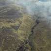
DP 025521 |
RCAHMS Aerial Photography Digital |
Oblique aerial view centred on the road bridge and the course of the military road, taken from the NW. |
4/4/2007 |
Item Level |
|
 |
On-line Digital Images |
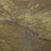
DP 025522 |
RCAHMS Aerial Photography Digital |
Oblique aerial view centred on the road bridge and the course of the military road, taken from the S. |
4/4/2007 |
Item Level |
|
|
Manuscripts |
MS 7779 |
General Collection |
Report: 'Corrieyairack Pass, Conservation and Management Study' |
5/1997 |
Item Level |
|
|
All Other |
551 260/4/1/38 |
Stuart Farrell |
Archive from archaeological watching brief on the Corrieyairack Pass, Highland |
20/6/2011 |
Sub-Group Level |
|


