
Pricing Change
New pricing for orders of material from this site will come into place shortly. Charges for supply of digital images, digitisation on demand, prints and licensing will be altered.
Lewis, Cnoc An Tursa


Pit(S) (Period Unassigned), Platform (Period Unassigned), Post Hole(S) (Period Unassigned)
Site Name Lewis, Cnoc An Tursa
Classification Pit(S) (Period Unassigned), Platform (Period Unassigned), Post Hole(S) (Period Unassigned)
Canmore ID 82977
Site Number NB23SW 29
NGR NB 21295 32950
Datum OSGB36 - NGR
Permalink http://canmore.org.uk/site/82977


- Council Western Isles
- Parish Uig
- Former Region Western Isles Islands Area
- Former District Western Isles
- Former County Ross And Cromarty
NB23SW 29 21295 32950
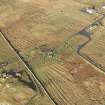
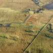
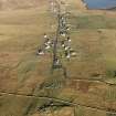
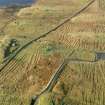
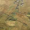
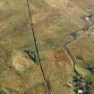
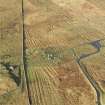
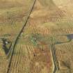
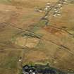
A flat platform below five large natural boulders to the S of Callanish 1 (NB23SW 1) and immediately outside the Historic Scotland protected area was investigated by excavation of an 'L'-shaped 2m by 10m by 10m trial trench. Two large pits (or ditch terminals?) were partially exposed at the N end of the trial trench. Immediately to the S of these pits lay a setting of four post-sockets in a shallow arc. On the E side of the site a shallow ditch running N to S and containing worked flint was discovered. Silting or backfilling of this ditch appears to have been followed by the erection of at least two phases of upright posts, the sockets of which cut through the ditch-fill into the underlying drift deposits. A spread of ash and charcoal was found to the E of these features. To the SW of the area bounded by the ditch and post-pit features a number of isolated post sockets were found.
Sponsors: University of Edinburgh, Historic Scotland
G M Coles 1993
Expansion of the trial trench opened in 1993 appears to confirm that the site represents a southern extension of NB23SW 1 and is probably broadly contemporaneous with it.
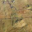
A 10m by 20m trench was opened and excavated to the underlying till. Features present in the subsoil and cut into the till were concentrated in the area immediately adjacent to the c 2m high rock wall of the roche moutonnee which forms the southern boundary of the site. Prehistoric activity appears to have been focused on a vertical fissure in this rock face.
The fissure contained a complex sequence of deposits. The upper part of the fissure was sealed with an evidently modern layer of organic silt containing sub-angular stones and bottle glass together with what appeared to be modern 'new age' offerings. This sealed several archaeologically sterile layers of coarse angular sands alternating with fine organic rich silts, possibly turf lines. Below these coarse sands and silts were a number of heart-like packings of flat stones set upon one another in a black charcoal-rich matrix. The dark matrix extended slightly beyond the fissure itself and overlay the edge of the fill of a c 2m diameter pit immediately in front of the fissure. This pit was haphazardly packed with possibly redeposited till.
The fill and edges of this pit feature were counter-cut by several pits and shallow scoops, previously noted in 1993, and which contained worked flint and pottery fragments of indeterminate type. The stratigraphic relationship suggests that the excavation of the large pit and its deliberate backfilling took place in antiquity. The location of the fissure and the pit on a direct alignment with the southern standing stone row of NB23SW1 may indicate that these features are contemporary.
Approximately 10m from the rock face and also on the alignment of the southern standing stone row was a large flat bottomed pit. This feature (part excavated in 1993) is thought on the basis of the presence of 'packing stones' and an irregular edge indicating removal damage to represent a previously unknown addition to this standing stone row. This stone is not indicated on any known historic plan or illustration of NB23SW 1. In 1993 a setting of four post-sockets in a shallow arc was noted immediately to the S of this pit; further possible post sockets were noted in 1994 but no convincing structure plan was evident.
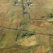
The western boundary of the site appears to be marked by a shallow ditch-like feature extending 3m N from the western end of the rock face. This feature was part exposed in 1993 and closer examination during 1994 has revealed that the apparent 'ditch' is composed of multiple counter-cutting post settings, sockets (with packing stones) and shallow scoops following the same alignment. At least two and possibly more phases of post replacement are indicated.
Pottery fragments of indeterminate type and worked stone were present in many of these features and they appear to mark some form of post built'wing wall'or screen along the eastern boundary of the central focus of the site. It is not known if these features are paralleled by a similar series to the W since this area has yet to be excavated and geophysical survey has so far proved ineffectual.
Sponsors: University of Edinburgh, Historic Scotland.
G M Coles and T Rees 1994.
Field Visit (2013)
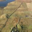
NB 21295 32950 and NB 21300 33017 A natural phenomenon has been observed close to the Callanish I monument which could be significant for the interpretation of the monument as a whole. Approximately 20m to the S of the monument lies Cnoc an Tursa, a hillock with distinctive rounded outcrops of bedrock – a Roche Moutonee. One large rounded block sits atop two others on the N side of the Cnoc, nearest the monument. Stones flanking this group create a group of five stones. The aperture between the first three forms a small, much discussed cave. When GM Coles and T Rees excavated trenches immediately N of the cave in 1993–4, they discovered many interesting features including rows of posts, pits and ditches containing pottery and flint. A continuity error in the 1994 DES report creates uncertainty about the position of pits and a ‘wing wall’, which could be on the W, E, or possibly both. It also doesn’t tell us whether the stones left in the cave were replaced exactly or just randomly backfilled. Nevertheless, this area has clearly been the focus of special attention at some point in the life of the monument.
Many monuments start life as natural places perceived to be special in some way and it is possible that this cave was such a place. It might also be worth noting the similarity between the cave and its flanking rocks with the entrance and forecourt of a chambered tomb.
Around midday on a bright sunny day in February, 2013, a defined beam or shaft of light was noticed by Ian Mchardy to be emanating from the back of the cave, around 50 to 150mm wide and stretching 2 or 3m out to the N onto the grass ‘forecourt’. The ‘forecourt’ area around the shaft was in deep shade, intensifying its effectiveness. The potential significance of this beam was realised and the discovery discussed with Margaret Curtis, who has documented it on bright days throughout 2013.
Investigation revealed that the bright sun was shining through a small slit between the rocks, which was further restricted by small trapped chock stones. The shaft moved W to E as the sun moved E to W, not unlike the hand of a clock. It was clear that this could only happen for a limited duration because of the sides of the cave – at around midday, from around 10.50 until 12.30 according to Margaret’s observations to date. Closest to midday the beam shines down directly into the cave, onto a step or seat like stone, as well as out onto the forecourt. Subsequent recording of the beam by Margaret has proved that the length of the beam and the surrounding shadow vary from summer to winter. In summer, the high sun casts a small shadow and beam, and in winter both beam and shadow are long.
Therefore these stones and the forecourt create a natural sundial, which with the addition of simple markers or posts in the ground at the various beam lengths on a N–S axis could tell not only the midday but the time or even month of the year.
Could this have possible in the Neolithic or before? The sun has changed only very slightly in declination since the Neolithic, about the width of their discs over the period since 2000 BC and so slightly more than this since 2,900 BC or before. The difference would mean that the sun and moon were slightly further S in rising and setting, hence only potentially negating the sun dials operation in midwinter, if the sun was so low that the Cnoc an Tursa cast a shadow over the group of five. This seems unlikely given the topography and magnitude of change.
Is this what the lines of pits or postholes found by Coles and Rees were? Access to a plan of their excavation may allow us to test this hypothesis, by comparing the excavated features with observation and recording of the actual sun beam through the year. An eight fold yearly division would require five post markers on a N–S line. Twelve months would be easily represented by seven posts, but 12 lunar months would fall just short of the solar year. A division of the year into 13 months would be rather difficult, because 8 posts would represent 14 months.
There is also a possibility that on the southern extreme of the moon, a bright full moon’s light could create a ‘moon beam’ allowing the setting to work as a ‘moondial’. Could this have led the builders of Callanish to understand the long, 18.6 year cycle of the moon, as has often been argued to be the case, but yet to be widely accepted? It is hard not to suggest that understanding this natural sun dial would pre-suppose a certain amount of knowledge and lead to a lot more knowledge of the cycles of the heavens. This knowledge would have been extremely useful to a farming population.
Ian McHardy and Margaret Curtis, 2013
(Source: DES)

